IMAGES TAKEN NEAR TO
Swainsford, WARMINSTER, BA12 6JU
Introduction
This page details the photographs taken nearby to Swainsford, BA12 6JU by members of the Geograph project.
The Geograph project started in 2005 with the aim of publishing, organising and preserving representative images for every square kilometre of Great Britain, Ireland and the Isle of Man.

There are currently over 7.5m images from over14,400 individuals and you can help contribute to the project by visiting https://www.geograph.org.uk
Image Map
Images are licensed for reuse under creativecommons.org/licenses/by-sa/2.0
Notes
- Clicking on the map will re-center to the selected point.
- The higher the marker number, the further away the image location is from the centre of the postcode.
Image Listing (5 Images Found)
Images are licensed for reuse under creativecommons.org/licenses/by-sa/2.0
Image
Details
Distance
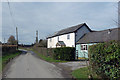
2
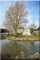
White Hill House
Next to White Hill Farm.
Image: © Des Blenkinsopp
Taken: 6 Mar 2017
0.09 miles
3
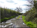
Horsington Lane
A public route with some sort of limitations, unspecified on map or on site.
Image: © Robin Webster
Taken: 2 Apr 2017
0.13 miles
5
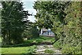
House and Lane at White Hill
One of the scattering of houses and farms which make up the hamlet of White Hill.
Image: © Des Blenkinsopp
Taken: 6 Mar 2017
0.20 miles