IMAGES TAKEN NEAR TO
North Street, WARMINSTER, BA12 6HU
Introduction
This page details the photographs taken nearby to North Street, BA12 6HU by members of the Geograph project.
The Geograph project started in 2005 with the aim of publishing, organising and preserving representative images for every square kilometre of Great Britain, Ireland and the Isle of Man.

There are currently over 7.5m images from over14,400 individuals and you can help contribute to the project by visiting https://www.geograph.org.uk
Image Map
Images are licensed for reuse under creativecommons.org/licenses/by-sa/2.0
Notes
- Clicking on the map will re-center to the selected point.
- The higher the marker number, the further away the image location is from the centre of the postcode.
Image Listing (222 Images Found)
Images are licensed for reuse under creativecommons.org/licenses/by-sa/2.0
Image
Details
Distance
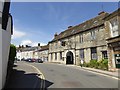
1
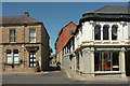
Manor Road, Mere
Leading off from the town centre and carrying the Mid Wilts Way - this is the starting point of the 68 mile route to Ham https://www.ldwa.org.uk/ldp/members/show_path.php?path_name=Mid+Wilts+Way .
On the right of the junction is the listed Walton Building, "A vigorous commercial design with high townscape value and well considered corner" https://www.historicengland.org.uk/listing/the-list/list-entry/1318646 .
On the left is the former Lloyds Bank.
Image: © Derek Harper
Taken: 29 Jun 2018
0.02 miles
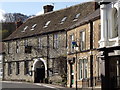
2
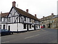
The George Inn, Mere
The building dates from the late 16th or early 17th century. It stands on the market square. For a view of the sign Image
Image: © Maigheach-gheal
Taken: 31 Jan 2011
0.02 miles
3
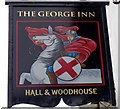
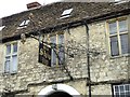
Sign for the George Inn
This sign for the inn replaces Image
Image: © Maigheach-gheal
Taken: 31 Jan 2011
0.02 miles
4
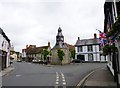
Mere, clock tower
In The Square, dated 1868. According to a plaque, a once adjacent building was used by the Dorset poet William Barnes as schoolhouse. Listed by English Heritage: http://www.imagesofengland.org.uk/Details/Default.aspx?id=320205&mode=adv
Image: © Mike Faherty
Taken: 3 Jun 2012
0.03 miles
5
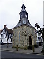
Clock tower, Mere
The clock tower stands on the site of the former market place. It is dated 1868 and has an Ordnance Survey flush bracket on its south east face.
Image: © Maigheach-gheal
Taken: 31 Jan 2011
0.03 miles
6
Inn sign
Elaborate ironwork defines the inn sign on the "Old Ship Inn" on Castle Street.
Image: © Oliver Dixon
Taken: 20 Jul 2018
0.03 miles
7
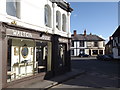
Walton House Antiques
Large shop on The Square at Mere. Angel Corner with its rea rooms is in the background.
http://merewilts.org/
Image: © Colin Smith
Taken: 21 Apr 2012
0.03 miles
10
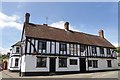
Old Ship Inn
Fine old coaching inn on Castle Street, Mere. This was once on the London-Exeter coach road.
http://merewilts.org/
Image: © Colin Smith
Taken: 21 Apr 2012
0.03 miles