IMAGES TAKEN NEAR TO
Shaftesbury Road, WARMINSTER, BA12 6BW
Introduction
This page details the photographs taken nearby to Shaftesbury Road, BA12 6BW by members of the Geograph project.
The Geograph project started in 2005 with the aim of publishing, organising and preserving representative images for every square kilometre of Great Britain, Ireland and the Isle of Man.

There are currently over 7.5m images from over14,400 individuals and you can help contribute to the project by visiting https://www.geograph.org.uk
Image Map
Images are licensed for reuse under creativecommons.org/licenses/by-sa/2.0
Notes
- Clicking on the map will re-center to the selected point.
- The higher the marker number, the further away the image location is from the centre of the postcode.
Image Listing (3 Images Found)
Images are licensed for reuse under creativecommons.org/licenses/by-sa/2.0
Image
Details
Distance
1

Postbox, Southbrook
A Victorian reign postbox set into a garden wall on Shaftesbury Road.
Image: © Maigheach-gheal
Taken: 18 Sep 2009
0.21 miles
2
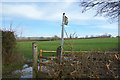
Muddy Footpath, White Hill
A large number of mostly quite short footpaths run all over this area.
Image: © Des Blenkinsopp
Taken: 6 Mar 2017
0.22 miles
3
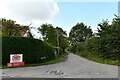
Huntingford: The point where White Hill Lane joins Shaftesbury Road
Image: © Michael Garlick
Taken: 29 Sep 2020
0.23 miles