IMAGES TAKEN NEAR TO
Burton, WARMINSTER, BA12 6BR
Introduction
This page details the photographs taken nearby to Burton, BA12 6BR by members of the Geograph project.
The Geograph project started in 2005 with the aim of publishing, organising and preserving representative images for every square kilometre of Great Britain, Ireland and the Isle of Man.

There are currently over 7.5m images from over14,400 individuals and you can help contribute to the project by visiting https://www.geograph.org.uk
Image Map
Images are licensed for reuse under creativecommons.org/licenses/by-sa/2.0
Notes
- Clicking on the map will re-center to the selected point.
- The higher the marker number, the further away the image location is from the centre of the postcode.
Image Listing (4 Images Found)
Images are licensed for reuse under creativecommons.org/licenses/by-sa/2.0
Image
Details
Distance
1
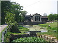
Millpond at Burton
A view looking to the southwest across the millpond at burton. The mill building in the background is now a private dwelling.
Image: © Phil Williams
Taken: 29 Apr 2007
0.05 miles
2
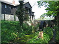
The Mill at Burton
A view looking to the northeast towards The Mill at Burton. This is now a private residence.
Image: © Phil Williams
Taken: 29 Apr 2007
0.05 miles
3
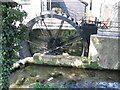
Waterwheel at Burton
A view looking north towards the waterwheel at The Mill at Burton.
Image: © Phil Williams
Taken: 29 Apr 2007
0.06 miles
4
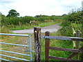
The Orange Way in Wiltshire (33)
The way goes ahead, crossing the lane called Southbrook.
Image: © Shazz
Taken: 26 Sep 2012
0.25 miles