IMAGES TAKEN NEAR TO
Sherrington, WARMINSTER, BA12 0SW
Introduction
This page details the photographs taken nearby to BA12 0SW by members of the Geograph project.
The Geograph project started in 2005 with the aim of publishing, organising and preserving representative images for every square kilometre of Great Britain, Ireland and the Isle of Man.

There are currently over 7.5m images from over14,400 individuals and you can help contribute to the project by visiting https://www.geograph.org.uk
Image Map
Images are licensed for reuse under creativecommons.org/licenses/by-sa/2.0
Notes
- Clicking on the map will re-center to the selected point.
- The higher the marker number, the further away the image location is from the centre of the postcode.
Image Listing (35 Images Found)
Images are licensed for reuse under creativecommons.org/licenses/by-sa/2.0
Image
Details
Distance
1
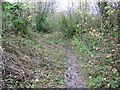
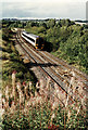
Bridleway, Sherrington
A rather narrow muddy bridleway, sunken with age and use heads to the valley road from Sherrington Dairy.
Image: © Maigheach-gheal
Taken: 2 Dec 2008
0.06 miles
2
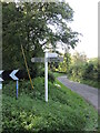
Junction and signpost near Sherrington
The road down the hill leads to Sherrington, and is one of two that go there.
Image: © Neil Owen
Taken: 29 Sep 2023
0.07 miles
3
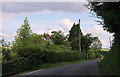
2011 : Mount Pleasant, Sherrington
The minor between Stockton and Boyton bypasses Sherrington which is lost in a maze of even more minor roads a few hundred yards to the north.
Image: © Maurice Pullin
Taken: 5 Aug 2011
0.08 miles
4
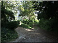
Restricted byway near Sherrington
A muddy, leafy track or two.
Image: © Neil Owen
Taken: 29 Sep 2023
0.09 miles
5
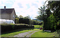
2011 : Church Lane, Sherrington
Heading south toward the main road.
A search of the www for Sherrington and/or its history reveals nothing, this in itself tells you something about the place.
Image: © Maurice Pullin
Taken: 24 Aug 2011
0.13 miles
6
Passing Sherrington
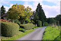
A class 158 diesel multiple unit bound for Portsmouth passes through the Wiltshire countryside. The trees in the middle distance mark the course of the River Wylye. The farm buildings on the horizon are on Knook Horse Hill.
Image: © Martin Addison
Taken: Unknown
0.16 miles
7
2011 : Footpath and track into Sherrington
West along the Wylye Valley. Meeting Church Lane.
Image: © Maurice Pullin
Taken: 24 Aug 2011
0.16 miles
8
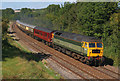
Rail Excursion at Sherington
Chartered train passing Albany Place, Sherington.
Image: © Wayland Smith
Taken: 15 Sep 2007
0.17 miles
9
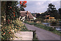
Sutton Hill, Sherrington - Sherrington Pond ca 1980
Image: © Ronald Searle
Taken: Unknown
0.19 miles
10
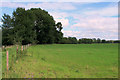
2011 : Field north east of Sherrington
The River Wylye flows through the trees on the far side.
Image: © Maurice Pullin
Taken: 24 Aug 2011
0.19 miles