IMAGES TAKEN NEAR TO
Albany Place, WARMINSTER, BA12 0SP
Introduction
This page details the photographs taken nearby to Albany Place, BA12 0SP by members of the Geograph project.
The Geograph project started in 2005 with the aim of publishing, organising and preserving representative images for every square kilometre of Great Britain, Ireland and the Isle of Man.

There are currently over 7.5m images from over14,400 individuals and you can help contribute to the project by visiting https://www.geograph.org.uk
Image Map
Images are licensed for reuse under creativecommons.org/licenses/by-sa/2.0
Notes
- Clicking on the map will re-center to the selected point.
- The higher the marker number, the further away the image location is from the centre of the postcode.
Image Listing (15 Images Found)
Images are licensed for reuse under creativecommons.org/licenses/by-sa/2.0
Image
Details
Distance
1
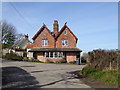
Albany Place
Originally two cottages, it must have been built on the original alignment of the road after it was diverted left to bridge the railway. It appears to be one house now, Albany Cottage.
Image: © Robin Webster
Taken: 2 Mar 2017
0.01 miles
2
2011 : Along the Wylye Valley near Sherrington
Image: © Maurice Pullin
Taken: 5 Aug 2011
0.06 miles
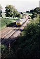
3
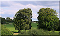
2011 : A view from the bridge
The railway bridge on the Warminster to Salisbury line near Sherrington.
Stockton Dairy can be seen between the trees, thought they were beeches at first but a closer inspection shows they are something else.
Image: © Maurice Pullin
Taken: 5 Aug 2011
0.06 miles
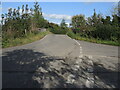
4
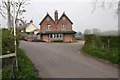
Sherrington
Albany Place at the minor road junction in the northeast of the square.
Image: © Brendan and Ruth McCartney
Taken: 24 Apr 2005
0.06 miles
5
Road junction and railway bridge near Albany Place
A short hump bridge to the village. From that parapet a vigilant observer will spot a rare projecting bracket trackside - see Image
Image: © Neil Owen
Taken: 29 Sep 2023
0.07 miles
6
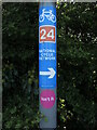
Isn't it
A national cycle route sign is wrapped around a slim pole. Isn't it.
Image: © Neil Owen
Taken: 29 Sep 2023
0.07 miles
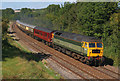
7
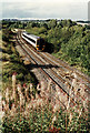
Empties to Westbury
A class 47 hauls a short train of empty stone wagons past Sherrington towards Westbury where much of this traffic from the mendip stone quarries is handled.
Image: © Martin Addison
Taken: Unknown
0.09 miles
8
Rail Excursion at Sherington
Chartered train passing Albany Place, Sherington.
Image: © Wayland Smith
Taken: 15 Sep 2007
0.09 miles
9
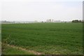
Passing Sherrington
A class 158 diesel multiple unit bound for Portsmouth passes through the Wiltshire countryside. The trees in the middle distance mark the course of the River Wylye. The farm buildings on the horizon are on Knook Horse Hill.
Image: © Martin Addison
Taken: Unknown
0.11 miles
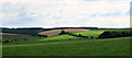
10
Sherrington
Looking northwest from the southeast corner of the square. About half of the square is farmland. We had hoped to see then Long Barrow marked on maps - this view shows that little of it is to be seen.
Image: © Brendan and Ruth McCartney
Taken: 24 Apr 2005
0.12 miles