IMAGES TAKEN NEAR TO
Fisherton De La Mere, WARMINSTER, BA12 0PX
Introduction
This page details the photographs taken nearby to BA12 0PX by members of the Geograph project.
The Geograph project started in 2005 with the aim of publishing, organising and preserving representative images for every square kilometre of Great Britain, Ireland and the Isle of Man.

There are currently over 7.5m images from over14,400 individuals and you can help contribute to the project by visiting https://www.geograph.org.uk
Image Map
Images are licensed for reuse under creativecommons.org/licenses/by-sa/2.0
Notes
- Clicking on the map will re-center to the selected point.
- The higher the marker number, the further away the image location is from the centre of the postcode.
Image Listing (3 Images Found)
Images are licensed for reuse under creativecommons.org/licenses/by-sa/2.0
Image
Details
Distance
1

Boundary post near Fisherton de la Mere
Cast iron T-shaped post from around 1840. One of series of cast-iron boundary posts and mileposts on turnpikes radiating from Warminster, made by Carson and Miller of Warminster. For a wider view see Image
Image: © Maigheach-gheal
Taken: 1 Jan 2010
0.16 miles
2
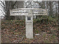
Old Boundary Marker by the A36, Salisbury Road, Codford
Parish Boundary Marker by the A36, in parish of Codford (West Wiltshire District), Salisbury Road, Codford. Junction with track to Starveall, on embankment.
Inscription reads:-
: CODFORD ST MARY : : FISHERTON / DE LA MER :
Grade II listed.
List Entry Number: 1181168 https://historicengland.org.uk/listing/the-list/list-entry/1181168
Surveyed
Milestone Society National ID: WI_SAWM12pb
Image: © Mike Faherty
Taken: 23 Feb 2008
0.16 miles
3
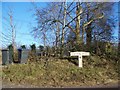
Boundary post near Fisherton de la Mere
Cast iron T-shaped post from around 1840. One of series of cast-iron boundary posts and mileposts on turnpikes radiating from Warminster, made by Carson and Miller of Warminster.
Image: © Maigheach-gheal
Taken: 1 Jan 2010
0.16 miles