IMAGES TAKEN NEAR TO
Chitterne Road, WARMINSTER, BA12 0PF
Introduction
This page details the photographs taken nearby to Chitterne Road, BA12 0PF by members of the Geograph project.
The Geograph project started in 2005 with the aim of publishing, organising and preserving representative images for every square kilometre of Great Britain, Ireland and the Isle of Man.

There are currently over 7.5m images from over14,400 individuals and you can help contribute to the project by visiting https://www.geograph.org.uk
Image Map
Images are licensed for reuse under creativecommons.org/licenses/by-sa/2.0
Notes
- Clicking on the map will re-center to the selected point.
- The higher the marker number, the further away the image location is from the centre of the postcode.
Image Listing (60 Images Found)
Images are licensed for reuse under creativecommons.org/licenses/by-sa/2.0
Image
Details
Distance
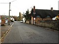
2

Thatched cottages, Codford St Mary
Rural housing.
Image: © Maigheach-gheal
Taken: 3 Sep 2008
0.05 miles
3
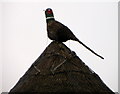
Thatch decoration, Codford St Mary
This pheasant is on the top of this cottage Image
Image: © Maigheach-gheal
Taken: 22 Jan 2011
0.06 miles
4
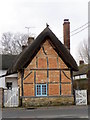
Timber-framed cottage, Codford St Mary
The 17th century cottages have a box-framework transmitting the weight of the roof to the round. This construction meant that non-structural materials could be used in the spaces between the framing - usually wattle and daub. During the late 17th century, this was often replaced with brickwork. These cottages have brick noggings on a rubble stone plinth.
Image: © Maigheach-gheal
Taken: 22 Jan 2011
0.06 miles
5

13 Codford
16th century cottage, originally had thatched roof
Image: © John Palmer
Taken: 13 Aug 2006
0.07 miles
6
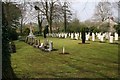
Codford St Mary
ANZAC War Graves cemetery near the church, a wonderfully peaceful place.
Image: © Brendan and Ruth McCartney
Taken: 24 Apr 2005
0.08 miles
7
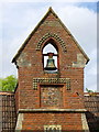
Bellcote, The Old School House
The bell to the former village school. For a wider view of the building Image
Image: © Maigheach-gheal
Taken: 16 Jun 2011
0.08 miles
8

The Old School House, Codford St Mary
This lovely building was once the village school. For a closer view of the bellcote Image
Image: © Maigheach-gheal
Taken: 16 Jun 2011
0.08 miles
9
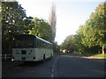
Sunny Autumn at Codford St Mary
Autumn sun casts strong shadows on the main road through Codford St Mary. Bristol RE bus DAE511K waits to return to Warminster on the vintage bus running day.
Image: © David Roberts
Taken: 12 Oct 2008
0.11 miles
10

Old Milepost, High Street, Codford
Cast iron post by the UC road (was A36), in parish of CODFORD (WEST WILTSHIRE District), High Street; Codford; 10m East of phone box opposite Old Manse, against sports field fence, on South-west side of road. C&M Classical iron casting, erected by the Fisherton, Wilton, Heytesbury, Willoughby Hedge & Redhone Turnpike Trust in the 19th century.
Inscription reads:-
SALISBURY
14
WARMINSTER
7
Grade II Listed. List Entry Number: 1036464
https://historicengland.org.uk/listing/the-list/list-entry/1036464
Milestone Society National ID: WI_SAWM14.
Image: © Milestone Society
Taken: 19 Mar 2017
0.12 miles