IMAGES TAKEN NEAR TO
Giggan Street, WARMINSTER, BA12 0PD
Introduction
This page details the photographs taken nearby to Giggan Street, BA12 0PD by members of the Geograph project.
The Geograph project started in 2005 with the aim of publishing, organising and preserving representative images for every square kilometre of Great Britain, Ireland and the Isle of Man.

There are currently over 7.5m images from over14,400 individuals and you can help contribute to the project by visiting https://www.geograph.org.uk
Image Map
Images are licensed for reuse under creativecommons.org/licenses/by-sa/2.0
Notes
- Clicking on the map will re-center to the selected point.
- The higher the marker number, the further away the image location is from the centre of the postcode.
Image Listing (31 Images Found)
Images are licensed for reuse under creativecommons.org/licenses/by-sa/2.0
Image
Details
Distance
1
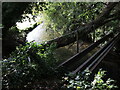
Rickety footbridge near Giggen Street
This crossing looks pretty unstable. A large tree appears to have come crashing down on the railing.
Image: © Neil Owen
Taken: 29 Sep 2023
0.02 miles
2
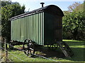
Shepherd's hut near Giggen Street
A mobile hut, unannounced on the path between the Codfords and Sherrington. No-one seemed home at the time.
Image: © Neil Owen
Taken: 29 Sep 2023
0.03 miles
3
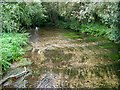
River Wylye, Codford St Mary
Taken looking upstream from the road bridge on Giggan Street.
Image: © Maigheach-gheal
Taken: 5 Sep 2010
0.06 miles
4
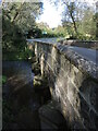
Giggen Street bridge
Sturdy piers for crossing the River Wylye. Note: the larger scale mapping shows 'Giggan Street', but zooming in shows 'Giggen Street'. Take your pick.
Image: © Neil Owen
Taken: 29 Sep 2023
0.07 miles
5
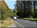
2011 : A36 on the Codford bypass heading east
The junction with the A303 in about five and a half miles (sorry cannot be more precise), on down the Wylye Valley then Salisbury.
The next turning right for Sherrington and Stockton then left for Codford.
Image: © Maurice Pullin
Taken: 18 Oct 2011
0.08 miles
6
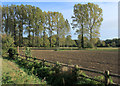
2011 : Ploughed field in the Wylye Valley
Seen from the A36 south of Codford St. Mary.
The River Wylye is beyond the trees.
Image: © Maurice Pullin
Taken: 18 Oct 2011
0.08 miles
7
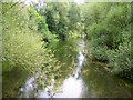
River Wylye, Codford St Mary
Taken looking downstream from the road bridge on Giggan Street. At this point the river runs parallel with the A36.
Image: © Maigheach-gheal
Taken: 5 Sep 2010
0.09 miles
8
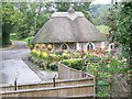
The end of the road, Codford St Mary
Sitting at the end of a minor road which has been blocked at its junction with the A36 is this pretty little thatched cottage.
Image: © Maigheach-gheal
Taken: 5 Sep 2010
0.10 miles
9
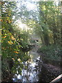
Chitterne Brook at Codford St Mary
Trees, beginning to turn gold in autumn, reflecting in the Chitterne Brook at Codford St Mary, where it flows between two roads.
Image: © David Roberts
Taken: 12 Oct 2008
0.11 miles
10
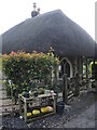
Duck eggs for sale
A thatched house (toll house?) at the entrance to Codford St Mary has a few tasty offerings for passing travellers. Presumably the large objects on the bottom shelf are marrows.
Image: © Neil Owen
Taken: 29 Sep 2023
0.12 miles