IMAGES TAKEN NEAR TO
Chitterne Road, WARMINSTER, BA12 0LZ
Introduction
This page details the photographs taken nearby to Chitterne Road, BA12 0LZ by members of the Geograph project.
The Geograph project started in 2005 with the aim of publishing, organising and preserving representative images for every square kilometre of Great Britain, Ireland and the Isle of Man.

There are currently over 7.5m images from over14,400 individuals and you can help contribute to the project by visiting https://www.geograph.org.uk
Image Map
Images are licensed for reuse under creativecommons.org/licenses/by-sa/2.0
Notes
- Clicking on the map will re-center to the selected point.
- The higher the marker number, the further away the image location is from the centre of the postcode.
Image Listing (4 Images Found)
Images are licensed for reuse under creativecommons.org/licenses/by-sa/2.0
Image
Details
Distance
1
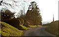
2011 : Chitterne Road near Auckland Farm
Looking south west into the setting sun.
Little more than a mile out of Codford St Mary.
Image: © Maurice Pullin
Taken: 30 Jan 2011
0.04 miles
2
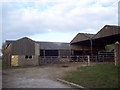
Farm Buildings near Codford St Peter
These buildings are part of Auckland Farm.
Image: © Maigheach-gheal
Taken: 20 Mar 2007
0.05 miles
3
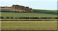
2011 : The valley of the Chitterne Brook
From a minor road near Auckland Farm.
The Chitterne Brook is a "winterbourne" being a stream or brook which dries up in summer months.
The brook occupies the ditch half way across the field with the remains of medieval strip farming.
Image: © Maurice Pullin
Taken: 30 Jan 2011
0.09 miles
4
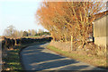
2011 : Chitterne Road passing Auckland Farm
A north/south minor road from Codford St.Mary to the south heading north to Chitterne.
An outbuilding of Auckland Farm is to the right.
Image: © Maurice Pullin
Taken: 30 Jan 2011
0.19 miles