IMAGES TAKEN NEAR TO
Chitterne Road, WARMINSTER, BA12 0LX
Introduction
This page details the photographs taken nearby to Chitterne Road, BA12 0LX by members of the Geograph project.
The Geograph project started in 2005 with the aim of publishing, organising and preserving representative images for every square kilometre of Great Britain, Ireland and the Isle of Man.

There are currently over 7.5m images from over14,400 individuals and you can help contribute to the project by visiting https://www.geograph.org.uk
Image Map
Images are licensed for reuse under creativecommons.org/licenses/by-sa/2.0
Notes
- Clicking on the map will re-center to the selected point.
- The higher the marker number, the further away the image location is from the centre of the postcode.
Image Listing (4 Images Found)
Images are licensed for reuse under creativecommons.org/licenses/by-sa/2.0
Image
Details
Distance
1
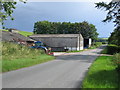
Approaching Punchbowl Farm
A view looking south along Chitterne Road near Punchbowl Farm.
Image: © Phil Williams
Taken: 3 Jul 2007
0.03 miles
2
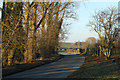
2011 : North on Chitterne Road
The road follows the valley of the Chitterne Brook between Codford St.Mary and Chitterne.
Image: © Maurice Pullin
Taken: 30 Jan 2011
0.07 miles
3
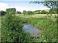
Chitterne Brook
A view looking to the northeast along Chitterne Brook from New Road.
Image: © Phil Williams
Taken: 3 Jul 2007
0.18 miles
4
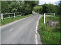
Culvert on New Road
A view looking to the east towards the culvert where Chitterne Brook passes under New Road. I assume that the concrete stump to the right is a remnant of wartime defences.
Image: © Phil Williams
Taken: 3 Jul 2007
0.21 miles