IMAGES TAKEN NEAR TO
The Stables, WARMINSTER, BA12 0LU
Introduction
This page details the photographs taken nearby to The Stables, BA12 0LU by members of the Geograph project.
The Geograph project started in 2005 with the aim of publishing, organising and preserving representative images for every square kilometre of Great Britain, Ireland and the Isle of Man.

There are currently over 7.5m images from over14,400 individuals and you can help contribute to the project by visiting https://www.geograph.org.uk
Image Map
Images are licensed for reuse under creativecommons.org/licenses/by-sa/2.0
Notes
- Clicking on the map will re-center to the selected point.
- The higher the marker number, the further away the image location is from the centre of the postcode.
Image Listing (12 Images Found)
Images are licensed for reuse under creativecommons.org/licenses/by-sa/2.0
Image
Details
Distance
1
![Chitterne houses [23]](https://s1.geograph.org.uk/geophotos/06/39/80/6398057_9b5ff2d3_120x120.jpg)
Chitterne houses [23]
Chitterne Lodge, in chequered flint and brick, is late 17th century with additions in the late 18th and early and late 19th centuries. Listed, grade II, with details at: https://historicengland.org.uk/listing/the-list/list-entry/1036437
Chitterne village lies in the middle of Salisbury Plain. Much of the parish is owned by the Ministry of Defence within the Salisbury Plain Training Area. The Imber firing range is to the north and the Copehill Down training area to the east. The Chitterne Brook, a small tributary of the River Wylye, flows through the village. There is a fine history of the village at: http://www.chitterne.com/history/index.html
Image: © Michael Dibb
Taken: 29 Jan 2020
0.05 miles
2
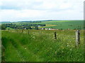
Chitterne viewed from the Imber perimeter path
Chitterne is an unpretentious little village tucked away in a valley.
Image: © Brian Robert Marshall
Taken: 3 Jun 2007
0.11 miles
3

Part of Chitterne viewed from the Imber perimeter path
Farm buildings and houses represent the character of this mid-Wiltshire village in its quiet little valley.
Image: © Brian Robert Marshall
Taken: 3 Jun 2007
0.11 miles
4
![Chitterne houses [22]](https://s3.geograph.org.uk/geophotos/06/39/80/6398055_b0b67896_120x120.jpg)
Chitterne houses [22]
Flint Cottage is dated circa 1850 and is a fine example of a small mid-Victorian vernacular cottage. Listed, grade II, with detgails at: https://historicengland.org.uk/listing/the-list/list-entry/1364347
Chitterne village lies in the middle of Salisbury Plain. Much of the parish is owned by the Ministry of Defence within the Salisbury Plain Training Area. The Imber firing range is to the north and the Copehill Down training area to the east. The Chitterne Brook, a small tributary of the River Wylye, flows through the village. There is a fine history of the village at: http://www.chitterne.com/history/index.html
Image: © Michael Dibb
Taken: 29 Jan 2020
0.13 miles
5
![Chitterne houses [24]](https://s2.geograph.org.uk/geophotos/06/39/80/6398062_9751ae35_120x120.jpg)
Chitterne houses [24]
A fine detached house alongside Chitterne Brook.
Chitterne village lies in the middle of Salisbury Plain. Much of the parish is owned by the Ministry of Defence within the Salisbury Plain Training Area. The Imber firing range is to the north and the Copehill Down training area to the east. The Chitterne Brook, a small tributary of the River Wylye, flows through the village. There is a fine history of the village at: http://www.chitterne.com/history/index.html
Image: © Michael Dibb
Taken: 29 Jan 2020
0.13 miles
6
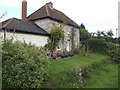
Robin's Nest
The name of this cottage in Chitterne. The low ground in the bottom right corner would be a part of the Chitterne Brook in winter.
Image: © Jonathan Billinger
Taken: 29 Aug 2007
0.14 miles
7
![Chitterne houses [21]](https://s0.geograph.org.uk/geophotos/06/39/80/6398052_48fc7eab_120x120.jpg)
Chitterne houses [21]
Flint House was once the home of the village forge. Built in the 18th century and much altered since the house has a 140 feet deep well.
Chitterne village lies in the middle of Salisbury Plain. Much of the parish is owned by the Ministry of Defence within the Salisbury Plain Training Area. The Imber firing range is to the north and the Copehill Down training area to the east. The Chitterne Brook, a small tributary of the River Wylye, flows through the village. There is a fine history of the village at: http://www.chitterne.com/history/index.html
Image: © Michael Dibb
Taken: 29 Jan 2020
0.14 miles
8
![Chitterne ways [8]](https://s1.geograph.org.uk/geophotos/06/39/80/6398061_d5b91809_120x120.jpg)
Chitterne ways [8]
The minor road runs through the village to Tilshead. Chitterne Brook flows alongside the road.
Chitterne village lies in the middle of Salisbury Plain. Much of the parish is owned by the Ministry of Defence within the Salisbury Plain Training Area. The Imber firing range is to the north and the Copehill Down training area to the east. The Chitterne Brook, a small tributary of the River Wylye, flows through the village. There is a fine history of the village at: http://www.chitterne.com/history/index.html
Image: © Michael Dibb
Taken: 29 Jan 2020
0.15 miles
9
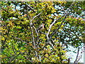
Chaffinch, on the Imber perimeter path near Chitterne
This is a male bird. The chaffinch is distinguished by the two white bars on its wings. More here http://www.garden-birds.co.uk/birds/chaffinch.htm
Image: © Brian Robert Marshall
Taken: 3 Jun 2007
0.16 miles
10
![Chitterne ways [9]](https://s0.geograph.org.uk/geophotos/06/39/87/6398780_79ade541_120x120.jpg)
Chitterne ways [9]
Pitts Lane leads from Townsend to Back Lane. Pitts House, on the left of the lane is dated 1891. There is another misplaced sign for the long distance Imber Range Perimeter Path which passes through Chitterne to the south.
Chitterne village lies in the middle of Salisbury Plain. Much of the parish is owned by the Ministry of Defence within the Salisbury Plain Training Area. The Imber firing range is to the north and the Copehill Down training area to the east. The Chitterne Brook, a small tributary of the River Wylye, flows through the village. There is a fine history of the village at: http://www.chitterne.com/history/index.html
Image: © Michael Dibb
Taken: 29 Jan 2020
0.18 miles