
IMAGES TAKEN NEAR TO
Chitterne, WARMINSTER, BA12 0LL
Introduction
This page details the photographs taken nearby to BA12 0LL by members of the Geograph project.
The Geograph project started in 2005 with the aim of publishing, organising and preserving representative images for every square kilometre of Great Britain, Ireland and the Isle of Man.

There are currently over 7.5m images from over14,400 individuals and you can help contribute to the project by visiting https://www.geograph.org.uk
Image Map
Images are licensed for reuse under creativecommons.org/licenses/by-sa/2.0
Notes
- Clicking on the map will re-center to the selected point.
- The higher the marker number, the further away the image location is from the centre of the postcode.
Image Listing (113 Images Found)
Images are licensed for reuse under creativecommons.org/licenses/by-sa/2.0
Image
Details
Distance
1
![Chitterne houses [7]](https://s3.geograph.org.uk/geophotos/06/39/56/6395695_4209b65e_120x120.jpg)
Chitterne houses [7]
Clump House is early 19th century and has some original internal features. Listed, grade II, with details at: https://historicengland.org.uk/listing/the-list/list-entry/1036444
Chitterne village lies in the middle of Salisbury Plain. Much of the parish is owned by the Ministry of Defence within the Salisbury Plain Training Area. The Imber firing range is to the north and the Copehill Down training area to the east. The Chitterne Brook, a small tributary of the River Wylye, flows through the village. There is a fine history of the village at: http://www.chitterne.com/history/index.html
Image: © Michael Dibb
Taken: 29 Jan 2020
0.01 miles
2
![Chitterne features [1]](https://s0.geograph.org.uk/geophotos/06/39/51/6395156_560cad74_120x120.jpg)
Chitterne features [1]
This 18th century bridge, seen here from the south, carries a former track over Chitterne Brook. See also Image Listed, grade II, with details at: https://historicengland.org.uk/listing/the-list/list-entry/1036448
Chitterne village lies in the middle of Salisbury Plain. Much of the parish is owned by the Ministry of Defence within the Salisbury Plain Training Area. The Imber firing range is to the north and the Copehill Down training area to the east. The Chitterne Brook, a small tributary of the River Wylye, flows through the village. There is a fine history of the village at: http://www.chitterne.com/history/index.html
Image: © Michael Dibb
Taken: 29 Jan 2020
0.02 miles
3
![Chitterne features [2]](https://s1.geograph.org.uk/geophotos/06/39/51/6395157_5928ba44_120x120.jpg)
Chitterne features [2]
This 18th century bridge, seen here from the north, carries a former track over Chitterne Brook. See also Image Listed, grade II, with details at: https://historicengland.org.uk/listing/the-list/list-entry/1036448
Chitterne village lies in the middle of Salisbury Plain. Much of the parish is owned by the Ministry of Defence within the Salisbury Plain Training Area. The Imber firing range is to the north and the Copehill Down training area to the east. The Chitterne Brook, a small tributary of the River Wylye, flows through the village. There is a fine history of the village at: http://www.chitterne.com/history/index.html
Image: © Michael Dibb
Taken: 29 Jan 2020
0.02 miles
4
![Chitterne houses [8]](https://s3.geograph.org.uk/geophotos/06/39/56/6395699_3297c812_120x120.jpg)
Chitterne houses [8]
Pear Tree House, number 96 Chitterne Road, is late 18th century, refenestrated in the late 19th century. Listed for group value, grade II, with details at: https://historicengland.org.uk/listing/the-list/list-entry/1036443
Chitterne village lies in the middle of Salisbury Plain. Much of the parish is owned by the Ministry of Defence within the Salisbury Plain Training Area. The Imber firing range is to the north and the Copehill Down training area to the east. The Chitterne Brook, a small tributary of the River Wylye, flows through the village. There is a fine history of the village at: http://www.chitterne.com/history/index.html
Image: © Michael Dibb
Taken: 29 Jan 2020
0.02 miles
5
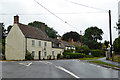
Houses at the junction, Chitterne
Where the road from Tilshead meets the B390.
Image: © Robin Webster
Taken: 21 Aug 2016
0.03 miles
6
![Chitterne houses [9]](https://s1.geograph.org.uk/geophotos/06/39/57/6395701_5aab1900_120x120.jpg)
Chitterne houses [9]
With a datestone of 1651, White Hart House was formerly the White Hart Inn which had closed by 1900. The building was altered in the 18th century and there is a 19th century rear extension and a 20th century extension to the right return. It is believed that Samuel Pepys spend the night in the inn in 1668. Listed, grade II, with details at: https://historicengland.org.uk/listing/the-list/list-entry/1364312
Chitterne village lies in the middle of Salisbury Plain. Much of the parish is owned by the Ministry of Defence within the Salisbury Plain Training Area. The Imber firing range is to the north and the Copehill Down training area to the east. The Chitterne Brook, a small tributary of the River Wylye, flows through the village. There is a fine history of the village at: http://www.chitterne.com/history/index.html
Image: © Michael Dibb
Taken: 29 Jan 2020
0.03 miles
7
![Chitterne features [7]](https://s3.geograph.org.uk/geophotos/06/39/57/6395703_cbe235b9_120x120.jpg)
Chitterne features [7]
In the centre of the village is this guide post, probably pre Worboys.
Chitterne village lies in the middle of Salisbury Plain. Much of the parish is owned by the Ministry of Defence within the Salisbury Plain Training Area. The Imber firing range is to the north and the Copehill Down training area to the east. The Chitterne Brook, a small tributary of the River Wylye, flows through the village. There is a fine history of the village at: http://www.chitterne.com/history/index.html
Image: © Michael Dibb
Taken: 29 Jan 2020
0.04 miles
9
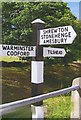
Old Direction Sign - Signpost by the B390, Chitterne
Pyramid top finial - 3 arms; Wilts. wooden post by the B390, in parish of Chitterne (West Wiltshire District), by junction with road to Tilshead.
Surveyed
Milestone Society National ID: WI_ST9943
Image: © Milestone Society
Taken: Unknown
0.05 miles
10
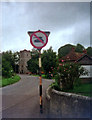
No tanks sign in Chitterne
In this small village on Salisbury Plain, surrounded by MoD land, military drivers are reminded that this road is strictly out of bounds to tanks.
Image: © Phil Champion
Taken: Unknown
0.05 miles