IMAGES TAKEN NEAR TO
Park Lane, WARMINSTER, BA12 0HE
Introduction
This page details the photographs taken nearby to Park Lane, BA12 0HE by members of the Geograph project.
The Geograph project started in 2005 with the aim of publishing, organising and preserving representative images for every square kilometre of Great Britain, Ireland and the Isle of Man.

There are currently over 7.5m images from over14,400 individuals and you can help contribute to the project by visiting https://www.geograph.org.uk
Image Map
Images are licensed for reuse under creativecommons.org/licenses/by-sa/2.0
Notes
- Clicking on the map will re-center to the selected point.
- The higher the marker number, the further away the image location is from the centre of the postcode.
Image Listing (31 Images Found)
Images are licensed for reuse under creativecommons.org/licenses/by-sa/2.0
Image
Details
Distance
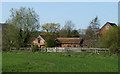
1

2011 : Spring in Park Lane
At the eastern end of Heytesbury heading south toward Corton and/or Tytherington.
Hope Alice Duer Miller and Nicholas Phipps will forgive me.
Image: © Maurice Pullin
Taken: 10 Apr 2011
0.03 miles
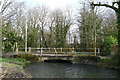
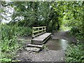
3
River Wylye seen from the Wessex Ridgeway
Taken from the bridge that takes the long distance footpath across the River Wylye.
Image: © Chris Heaton
Taken: 12 Feb 2020
0.07 miles
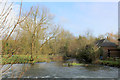
4
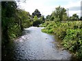
River Wylye, Heytesbury
The Wylye is generally regarded as the most notable of the Avon tributaries. It rises five miles south of Warminster and flows north to the town; this uppermost reach is sometimes referred to as 'The Deverill Brook'. Turning westward, it flows for another sixteen miles to join the Nadder just below Wilton, shortly before the latter reaches the Avon at Salisbury a mile or so further on.
Looking upstream.
Image: © Maigheach-gheal
Taken: 8 Sep 2009
0.09 miles
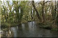
5
River Wylye at Mill Farm
The Wylye is generally regarded as the most notable of the Avon tributaries.
Image: © Maigheach-gheal
Taken: 22 Jul 2011
0.10 miles
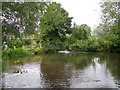
6
2011 : Mill Farm, near Heytesbury
Once the site of a mill on the River Wylye.
Image: © Maurice Pullin
Taken: 10 Apr 2011
0.10 miles
7
Ford at Heytesbury
A video of this ford at Heytesbury can be viewed at:
https://youtu.be/qnUY_8u5kaA
Image: © John Walton
Taken: 6 Aug 2023
0.10 miles
9

2011 : The A36 was here, Heytesbury
The old route of the A36, Park Street, barricaded off to avoid misunderstandings at the end of the bypass which replaces it.
There is an alternative way onto the A36 at the eastern end of the village but for anyone travelling east toward Salisbury at times of heavy traffic it would be safer and maybe quicker to go to the roundabout at the western end of the bypass.
Image: © Maurice Pullin
Taken: 10 Apr 2011
0.12 miles
10
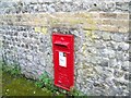
Postbox, Heytesbury
A George V reign postbox in Park Street, the former A36.
Image: © Maigheach-gheal
Taken: 8 Sep 2009
0.12 miles