IMAGES TAKEN NEAR TO
Station Road, WARMINSTER, BA12 0FB
Introduction
This page details the photographs taken nearby to Station Road, BA12 0FB by members of the Geograph project.
The Geograph project started in 2005 with the aim of publishing, organising and preserving representative images for every square kilometre of Great Britain, Ireland and the Isle of Man.

There are currently over 7.5m images from over14,400 individuals and you can help contribute to the project by visiting https://www.geograph.org.uk
Image Map
Images are licensed for reuse under creativecommons.org/licenses/by-sa/2.0
Notes
- Clicking on the map will re-center to the selected point.
- The higher the marker number, the further away the image location is from the centre of the postcode.
Image Listing (6 Images Found)
Images are licensed for reuse under creativecommons.org/licenses/by-sa/2.0
Image
Details
Distance
1
Site of Codford station, 1984
View SE, towards Salisbury: ex-GWR Westbury - Salisbury secondary main line. The line is still an important link, but this station was closed to passengers 19/9/55 and goods 10/6/63. Nothing seems to be left.
Image: © Ben Brooksbank
Taken: 30 Aug 1984
0.07 miles
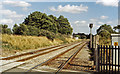
2
Level Crossing near Codford St Peter
Image: © Maigheach-gheal
Taken: 3 Feb 2007
0.12 miles
3
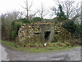
Pillbox, Codford St Peter
The pillbox is near the Codford Water Treatment Works.
Image: © Maigheach-gheal
Taken: 22 Jan 2011
0.12 miles
4
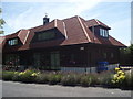
Country Gentleman's Association HQ
An organisation promoting country sports and lifestyles. Its prides itself that when you ring up you either get an engaged tone or a real person answers the telephone.
Image: © Basher Eyre
Taken: 10 Aug 2007
0.15 miles
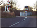
5
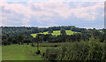
2011 : Across the Wylye Valley from the A36
At the junction with Station Road.
The sunlit hill overlooks Boyton.
Image: © Maurice Pullin
Taken: 24 Aug 2011
0.24 miles
6
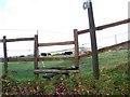
Stile, Codford St Peter
The stile gives access to the footpath that cross fields towards Upton Lovall. An electric fence has to be negotiated before passing through the herd of cows.
Image: © Maigheach-gheal
Taken: 23 Nov 2009
0.24 miles