IMAGES TAKEN NEAR TO
Lime Kiln Close, WARMINSTER, BA12 0EX
Introduction
This page details the photographs taken nearby to Lime Kiln Close, BA12 0EX by members of the Geograph project.
The Geograph project started in 2005 with the aim of publishing, organising and preserving representative images for every square kilometre of Great Britain, Ireland and the Isle of Man.

There are currently over 7.5m images from over14,400 individuals and you can help contribute to the project by visiting https://www.geograph.org.uk
Image Map
Images are licensed for reuse under creativecommons.org/licenses/by-sa/2.0
Notes
- Clicking on the map will re-center to the selected point.
- The higher the marker number, the further away the image location is from the centre of the postcode.
Image Listing (8 Images Found)
Images are licensed for reuse under creativecommons.org/licenses/by-sa/2.0
Image
Details
Distance
1
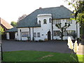
Art Deco house, Westbury Road, Warminster
This art deco house built in the 1930's incorporates a staircase that winds its way up the turret. Now a guest house, see: http://www.lioncountry.co.uk/ that includes a photo of the rear of the house.
Image: © Alan Cooper
Taken: 10 Oct 2010
0.03 miles
2
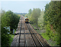
2010 : Local train approaching Warminster
From Dilton Marsh and Westbury.
The bridge carrying the A350 Warminster/Westbury bypass is in the distance.
Image: © Maurice Pullin
Taken: 4 May 2010
0.05 miles
3

2010 : Local train on the way to Warminster station
Looking south east from a footbridge over the main line between Westbury and Salisbury.
Image: © Maurice Pullin
Taken: 4 May 2010
0.12 miles
4
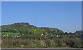
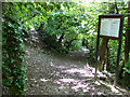
Arn Hill, Warminster
Looking to the east, the telecoms mast can be seen above the autumn foliage covering the slopes of Arn Hill, Warminster.
Image: © Phil Williams
Taken: 15 Oct 2005
0.16 miles
5
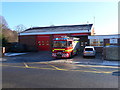
Warminster -Fire Station
As I was passing a flurry of activity resulted in this shot of the engine on its way to a shout.
Image: © Chris Talbot
Taken: 30 Jan 2010
0.19 miles
7
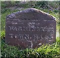
Old Milestone by Westbury Road, Warminster Parish
Metal plate attached to stone post by the UC road, in parish of WARMINSTER (WEST WILTSHIRE District), Westbury Road; 200m South of New Farm, by the road, on East side of road. Warminster plate, erected by the Warminster turnpike trust in the 19th century.
Inscription reads:-
WARMINSTER
TOWN.HALL
1
WESTBURY
(3)
Milestone Society National ID: WI_WMWB01.
Image: © M Faherty
Taken: 8 Apr 2007
0.21 miles
8
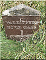
Old Milestone by Westbury Road, Warminster Parish
Metal plate attached to stone post by the UC road, in parish of WARMINSTER (WEST WILTSHIRE District), Westbury Road; 200m South of New Farm, by the road, on East side of road. Warminster plate, erected by the Warminster turnpike trust in the 19th century.
Inscription reads:-
WARMINSTER
TOWN.HALL
1
WESTBURY
(3)
Milestone Society National ID: WI_WMWB01.
Image: © Gail Fawcett
Taken: 24 Sep 2023
0.21 miles