IMAGES TAKEN NEAR TO
Norton Bavant, WARMINSTER, BA12 0EP
Introduction
This page details the photographs taken nearby to BA12 0EP by members of the Geograph project.
The Geograph project started in 2005 with the aim of publishing, organising and preserving representative images for every square kilometre of Great Britain, Ireland and the Isle of Man.

There are currently over 7.5m images from over14,400 individuals and you can help contribute to the project by visiting https://www.geograph.org.uk
Image Map
Images are licensed for reuse under creativecommons.org/licenses/by-sa/2.0
Notes
- Clicking on the map will re-center to the selected point.
- The higher the marker number, the further away the image location is from the centre of the postcode.
Image Listing (8 Images Found)
Images are licensed for reuse under creativecommons.org/licenses/by-sa/2.0
Image
Details
Distance
1
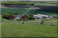
North Farm
AS seen from the ramparts of Scratchbury Camp - an Iron Age Hillfort on the edge of Salisbury Plain
Image: © Chris Heaton
Taken: 17 May 2021
0.01 miles
2
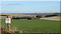
2011 : North Farm surrounded by fields
The Imber Military Range beyond the road in the distance to the left.
The field in the immediate foreground has been fairly recently sown, can be seen in Image
The notice is connected with the Military Range, probably refers to a schedule of some sort.
Image: © Maurice Pullin
Taken: 30 Jan 2011
0.04 miles
3
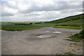
Track to North Farm
North farm is amongst the trees centre left. For a similar view 2½ years earlier see Image
Image: © Roger Gittins
Taken: 20 May 2009
0.05 miles
4
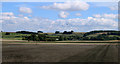
2011 : Cropped field near North Farm
Probably oilsee rape, much too early for maize.
Five rooks hover hopefully. Scratchbury Hill is behind.
Image: © Maurice Pullin
Taken: 24 Aug 2011
0.22 miles
5

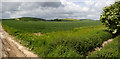
Farmland
Image: © Roger Gittins
Taken: 20 May 2009
0.22 miles
6
North Farm Panorama 4
Image: © Roger Gittins
Taken: 20 May 2009
0.22 miles
7

Track to North Farm
Image: © Roger Gittins
Taken: 20 May 2009
0.23 miles
8

New crop
Image: © Roger Gittins
Taken: 20 May 2009
0.23 miles