IMAGES TAKEN NEAR TO
Station Road, WARMINSTER, BA12 0EH
Introduction
This page details the photographs taken nearby to Station Road, BA12 0EH by members of the Geograph project.
The Geograph project started in 2005 with the aim of publishing, organising and preserving representative images for every square kilometre of Great Britain, Ireland and the Isle of Man.

There are currently over 7.5m images from over14,400 individuals and you can help contribute to the project by visiting https://www.geograph.org.uk
Image Map
Images are licensed for reuse under creativecommons.org/licenses/by-sa/2.0
Notes
- Clicking on the map will re-center to the selected point.
- The higher the marker number, the further away the image location is from the centre of the postcode.
Image Listing (4 Images Found)
Images are licensed for reuse under creativecommons.org/licenses/by-sa/2.0
Image
Details
Distance
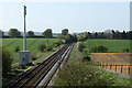
1

Site of former Heytesbury station
View NW, towards Westbury: ex-GWR (Bristol etc.) - Westbury - Salisbury secondary main line. The station was closed 19/9/55, but the line remains an important link to Southampton etc. from Bristol and South Wales.
Image: © Ben Brooksbank
Taken: 1 Jun 1994
0.03 miles
2
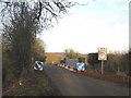
Weak bridge
A view looking northeast long the minor road from Tytherington to Heytesbury, where the road crosses the railway via this weight restricted bridge.
Image: © Phil Williams
Taken: 22 Jan 2006
0.08 miles
3
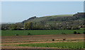
2011 : North of west from a railway bridge south of Heytesbury
Looking up the Wylye Valley.
Warminster is mostly hidden in the trees middle distance but the wood near the top of Arn Hill Down Image is clearly visible.
Image: © Maurice Pullin
Taken: 10 Apr 2011
0.10 miles
4
2011 : Railway line to Warminster and Westbury
Seen from an overbridge south of Heytesbury.
The large post to the left seems to be some sort of communications mast.
Image: © Maurice Pullin
Taken: 10 Apr 2011
0.14 miles