IMAGES TAKEN NEAR TO
High Street, WARMINSTER, BA12 0EB
Introduction
This page details the photographs taken nearby to High Street, BA12 0EB by members of the Geograph project.
The Geograph project started in 2005 with the aim of publishing, organising and preserving representative images for every square kilometre of Great Britain, Ireland and the Isle of Man.

There are currently over 7.5m images from over14,400 individuals and you can help contribute to the project by visiting https://www.geograph.org.uk
Image Map
Images are licensed for reuse under creativecommons.org/licenses/by-sa/2.0
Notes
- Clicking on the map will re-center to the selected point.
- The higher the marker number, the further away the image location is from the centre of the postcode.
Image Listing (93 Images Found)
Images are licensed for reuse under creativecommons.org/licenses/by-sa/2.0
Image
Details
Distance
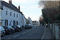
1
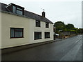
Looking east-northeast in the High Street
Image: © Basher Eyre
Taken: 13 Sep 2013
0.00 miles
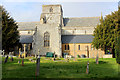
2
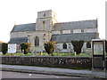
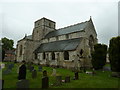
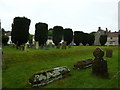
The Church of St Peter and St Paul at Heytesbury
Viewed from the north-west.
Image: © Peter Wood
Taken: 13 Feb 2017
0.02 miles
4
Heytesbury, SS Peter & Paul
Parish church on High Street, dating from C12; listed by Historic England (Grade I): http://www.imagesofengland.org.uk/Details/Default.aspx?id=313280&mode=adv
Image: © Mike Faherty
Taken: 26 Aug 2017
0.02 miles
5
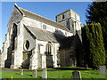
The Church of St Peter and St Paul
The church has its origins in the 12th century. During the following centuries further building took place. A period of restoration took place in 1864 to 1867 by W. Butterfield. The church has a cruciform plan and is built of limestone, rubble stone and ashlar.
Image: © Maigheach-gheal
Taken: 12 Dec 2010
0.02 miles
6
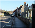
2011 : High Street, Heytesbury looking east
"The village of Heytesbury is a very ancient one. It is mentioned in the Domesday Book as Hestrebe, but Sir Richard Colt Hoare of Stourhead, wrote in 1824 in his “History of Modern Wiltshire and the Hundred of Heytesbury” employed in the compiling of the Domesday Book softened the rough Saxon Hestredesbirig into Haseberie. The late Lord Heytesbury wrote “John Britton” writing in 1814, gives Haresbury as a variation in use. In the last century Heytesbury was often pronounced ‘Hettsbury’."
The above was copied from: http://www.heytesburyparish.co.uk/LocalHistory.htm where there is much more.
Image: © Maurice Pullin
Taken: 30 Jan 2011
0.03 miles
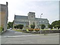
7
St Peter and St Paul, Heytesbury; September 2013
Image: © Basher Eyre
Taken: 13 Sep 2013
0.03 miles
9
2011 : High Street, Heytesbury looking west
Formerly the A36. Imagine this, if you will, with all the traffic between Warminster and Salisbury piling through and be thankful for bypasses.
Image: © Maurice Pullin
Taken: 30 Jan 2011
0.03 miles
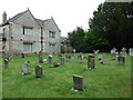
10
Church of St. Peter and St. Paul, Heytesbury
It was a collegiate church from the 12th century until 1840. The present building is largely 13th-century and is designated as Grade I listed.
Image: © Chris Heaton
Taken: 12 Feb 2020
0.03 miles