IMAGES TAKEN NEAR TO
Morley Field, WARMINSTER, BA12 0BU
Introduction
This page details the photographs taken nearby to Morley Field, BA12 0BU by members of the Geograph project.
The Geograph project started in 2005 with the aim of publishing, organising and preserving representative images for every square kilometre of Great Britain, Ireland and the Isle of Man.

There are currently over 7.5m images from over14,400 individuals and you can help contribute to the project by visiting https://www.geograph.org.uk
Image Map
Images are licensed for reuse under creativecommons.org/licenses/by-sa/2.0
Notes
- Clicking on the map will re-center to the selected point.
- The higher the marker number, the further away the image location is from the centre of the postcode.
Image Listing (26 Images Found)
Images are licensed for reuse under creativecommons.org/licenses/by-sa/2.0
Image
Details
Distance
1
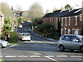
2008 : The road to Warminster Training Centre
The bottom of Sack Hill.
Image: © Maurice Pullin
Taken: 19 Nov 2008
0.06 miles
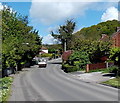
2
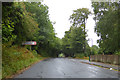
Imber Road, Warminster
To the left down Imber Avenue are, according to the sign, Land Training Fleet (W) DSG Warminster HQ LF ECI Team. I am not sure where any commas come in that lot.
Image: © Robin Webster
Taken: 21 Aug 2016
0.14 miles
3
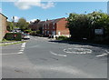
Imber Road and Copheap Lane mini-roundabout in Warminster
Copheap Lane, from the left, joins Imber Road.
Image: © Jaggery
Taken: 9 May 2014
0.14 miles
4

Postbox in a hedge, Warminster
On the corner of Copheap Lane and Imber Road (ahead).
The hedge appears to have been recently pruned, so today it is the postbox at the edge of a hedge.
Image: © Jaggery
Taken: 9 May 2014
0.15 miles
5

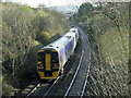
Railway east of Imber Road, Warminster
Warminster railway station is about 300 metres behind the camera.
Image: © Jaggery
Taken: 9 May 2014
0.15 miles
6
2008 : Railway bridge, Sack Hill, Warminster
This local train heading south east has just left Warminster station.
Image: © Maurice Pullin
Taken: 19 Nov 2008
0.15 miles
7
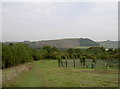
View to Battlesbury
Taken from Cop Heap, near to the fenced off compound.
Image: © Neil Owen
Taken: 27 Sep 2013
0.15 miles
8
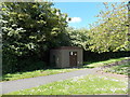
Gas Installation, Copheap Lane, Warminster
Located at the edge of Copheap Lane, near the Imber Road junction. The identifier on the Wales & West Utilities (WWU) gas installation is IMBER ROAD (JCN COPH). An EX in a black-lined yellow triangle indicates a potentially explosive atmosphere - smoking prohibited. A notice shows a WWU Plant Protection phone number to ring before beginning any works on, or within 10 metres of, this site.
Image: © Jaggery
Taken: 9 May 2014
0.16 miles
9
Copheap Lane, Warminster
Copheap Lane heads NNW away from Imber Road.
Image: © Jaggery
Taken: 9 May 2014
0.16 miles
10
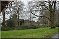
Roadside green space and military housing, Imber Road
Image: © David Martin
Taken: 1 Jan 2024
0.16 miles