IMAGES TAKEN NEAR TO
Pennings Lane, BA12 0BR
Introduction
This page details the photographs taken nearby to Pennings Lane, BA12 0BR by members of the Geograph project.
The Geograph project started in 2005 with the aim of publishing, organising and preserving representative images for every square kilometre of Great Britain, Ireland and the Isle of Man.

There are currently over 7.5m images from over14,400 individuals and you can help contribute to the project by visiting https://www.geograph.org.uk
Image Map
Images are licensed for reuse under creativecommons.org/licenses/by-sa/2.0
Notes
- Clicking on the map will re-center to the selected point.
- The higher the marker number, the further away the image location is from the centre of the postcode.
Image Listing (10 Images Found)
Images are licensed for reuse under creativecommons.org/licenses/by-sa/2.0
Image
Details
Distance
1
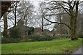
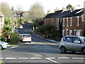
Roadside green space and military housing, Imber Road
Image: © David Martin
Taken: 1 Jan 2024
0.08 miles
2
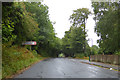
Imber Road, Warminster
To the left down Imber Avenue are, according to the sign, Land Training Fleet (W) DSG Warminster HQ LF ECI Team. I am not sure where any commas come in that lot.
Image: © Robin Webster
Taken: 21 Aug 2016
0.09 miles
3

Old Milepost by Imber Road, Warminster parish
Cast iron post by the UC road, in parish of WARMINSTER (WEST WILTSHIRE District), Imber road, Warminster; 200m West of church, next to bus stop on verge, on Southeast side of road. C&M Classical iron casting, erected by the Warminster turnpike trust in the 19th century.
Inscription reads:-
WARMINSTER
TOWN.HALL
1
MILE
IMBER
5
MILES
Grade II listed.
List Entry Number: 1036219 https://historicengland.org.uk/listing/the-list/list-entry/1036219
Milestone Society National ID: WI_WMIM01.
Image: © M Faherty
Taken: 8 Apr 2007
0.15 miles

5
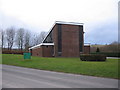
St. Giles Garrison Church
A view looking west across Imber Road to the garrison church of St. Giles.
Image: © Phil Williams
Taken: 28 Mar 2006
0.20 miles
6
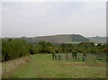
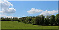
View to Battlesbury
Taken from Cop Heap, near to the fenced off compound.
Image: © Neil Owen
Taken: 27 Sep 2013
0.21 miles
7
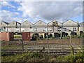
2008 : The road to Warminster Training Centre
The bottom of Sack Hill.
Image: © Maurice Pullin
Taken: 19 Nov 2008
0.22 miles
10
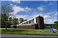
Garrison church of St Giles, Warminster
Dedicated in 1968, with its foundation stone and dedication name coming from the Church of St. Giles at Imber, a village in the middle of Salisbury Plain taken over by the army in 1944 https://history.wiltshire.gov.uk/community/getchurch.php?id=395
Image: © Tim Heaton
Taken: 17 May 2021
0.24 miles