IMAGES TAKEN NEAR TO
The Downlands, WARMINSTER, BA12 0BD
Introduction
This page details the photographs taken nearby to The Downlands, BA12 0BD by members of the Geograph project.
The Geograph project started in 2005 with the aim of publishing, organising and preserving representative images for every square kilometre of Great Britain, Ireland and the Isle of Man.

There are currently over 7.5m images from over14,400 individuals and you can help contribute to the project by visiting https://www.geograph.org.uk
Image Map
Images are licensed for reuse under creativecommons.org/licenses/by-sa/2.0
Notes
- Clicking on the map will re-center to the selected point.
- The higher the marker number, the further away the image location is from the centre of the postcode.
Image Listing (60 Images Found)
Images are licensed for reuse under creativecommons.org/licenses/by-sa/2.0
Image
Details
Distance
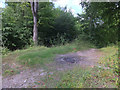
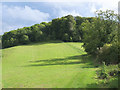
2
A lump in the landscape
The steeper banks of earth at the top of Cop Heap are part of the tumulus. See Image] for another view.
Image: © Neil Owen
Taken: 27 Sep 2013
0.08 miles
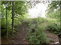
3
Cop Heap barrow
At the summit of the hill overlooking Warminster is this round barrow. It is approximately 3m above ground level and 20m in diameter. The tumulus was excavated in 1809 by William Cunnington and Richard Colt Hoare, two of the area's most eager antiquarians and whose works include Stonehenge. See Image] for another view.
Image: © Neil Owen
Taken: 27 Sep 2013
0.08 miles
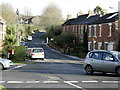
4
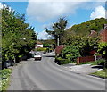
Copheap Lane, Warminster
Copheap Lane heads NNW away from Imber Road.
Image: © Jaggery
Taken: 9 May 2014
0.10 miles
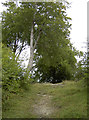
5
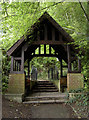
Copheap lychgate
This humble lychgate is far from a church, oddly enough. It is in fact a war memorial, built in the years after WWII. See Image] for the path and more details.
Image: © Neil Owen
Taken: 27 Sep 2013
0.11 miles
6
2008 : The road to Warminster Training Centre
The bottom of Sack Hill.
Image: © Maurice Pullin
Taken: 19 Nov 2008
0.13 miles
7
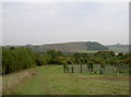
View to Battlesbury
Taken from Cop Heap, near to the fenced off compound.
Image: © Neil Owen
Taken: 27 Sep 2013
0.13 miles
9
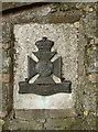
Wiltshire Regiment Badge
One of two military emblems on the memorial path at Copheap. See Image] for the other.
Image: © Neil Owen
Taken: 27 Sep 2013
0.15 miles
10

Do you like my new outfit?
Two ladybirds (Coccinellidae sp.) of differing colours meet at the bottom of Copheap memorial path. There were dozens of them on the railings, and a few varieties at that. See Image] for more.
Image: © Neil Owen
Taken: 27 Sep 2013
0.15 miles