IMAGES TAKEN NEAR TO
Upton Scudamore, WARMINSTER, BA12 0AE
Introduction
This page details the photographs taken nearby to BA12 0AE by members of the Geograph project.
The Geograph project started in 2005 with the aim of publishing, organising and preserving representative images for every square kilometre of Great Britain, Ireland and the Isle of Man.

There are currently over 7.5m images from over14,400 individuals and you can help contribute to the project by visiting https://www.geograph.org.uk
Image Map
Images are licensed for reuse under creativecommons.org/licenses/by-sa/2.0
Notes
- Clicking on the map will re-center to the selected point.
- The higher the marker number, the further away the image location is from the centre of the postcode.
Image Listing (23 Images Found)
Images are licensed for reuse under creativecommons.org/licenses/by-sa/2.0
Image
Details
Distance

3
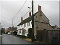
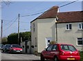
Houses at Upton Scudamore
Looking west
Image: © M J Richardson
Taken: 24 Dec 2015
0.15 miles
4
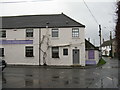
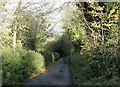
Toll house, Upton Scudamore
Difficult to believe that this was a toll house, as it looks like a rural bywater; but the A350 roars by a hundred yards away, where it was realigned. Pentagonal in plan & added onto an existing row of cottages; built by the Warminster Roads turnpike trust.
http://www.wiltshire.gov.uk/community/getcom.php?id=231
Image: © Mike Faherty
Taken: 8 Apr 2007
0.16 miles
5
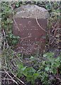
Old Milestone on old road by Halfway Farm, Upton Scudamore Parish
Metal plate attached to stone post by the UC road, in parish of UPTON SCUDAMORE (WEST WILTSHIRE District), old main road past Halfway Farm; 5m North of gated farm road and entrance, half-hidden in embankment, on East side of road. Warminster plate, erected by the Warminster turnpike trust in the 18th century.
Inscription reads:-
Warminfter
2
Weftbury
2
Grade II listed. List Entry Number: 1181740
https://historicengland.org.uk/listing/the-list/list-entry/1181740
Milestone Society National ID: WI_WMWB02.
Image: © M Faherty
Taken: 8 Apr 2007
0.17 miles
6
Old Milestone on old road by Halfway Farm, Upton Scudamore Parish
Metal plate attached to stone post by the UC road, in parish of UPTON SCUDAMORE (WEST WILTSHIRE District), old main road past Halfway Farm; 5m North of gated farm road and entrance, half-hidden in embankment, on East side of road. Warminster plate, erected by the Warminster turnpike trust in the 18th century.
Inscription reads:-
Warminfter
2
Weftbury
2
Grade II listed. List Entry Number: 1181740
https://historicengland.org.uk/listing/the-list/list-entry/1181740
Milestone Society National ID: WI_WMWB02.
Image: © Spike Johnson
Taken: 24 Sep 2023
0.17 miles

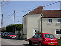
8
Old Toll House by Warminster Road, Upton Scudamore
Upton Scudamore (calloway) by the UC road (was A350), in parish of Upton Scudamore (West Wiltshire District), Halfway cottages, Warminster Road.
To be surveyed
Milestone Society National ID: WI.USC
Image: © Milestone Society
Taken: Unknown
0.17 miles
9
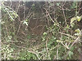
2008 : Down to the bottom
Biss Bottom to be precise. The source of the River Biss.
Image: © Maurice Pullin
Taken: 19 Nov 2008
0.17 miles
10
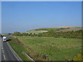
Upton Cow Down
Looking north from the bridge over the A350 at Upton Scudamore towards Upton Cow Down, part of the western edge of Salisbury Plain. The southbound white lorry has just traversed the embankment over Biss Bottom.
Image: © Phil Williams
Taken: 15 Oct 2005
0.18 miles