IMAGES TAKEN NEAR TO
Charles Street, BATH, BA1 1HX

Introduction

This page details the photographs taken nearby to Charles Street, BA1 1HX by members of the Geograph project.

The Geograph project started in 2005 with the aim of publishing, organising and preserving representative images for every square kilometre of Great Britain, Ireland and the Isle of Man.

There are currently over 7.5m images from over14,400 individuals and you can help contribute to the project by visiting https://www.geograph.org.uk

Image Map


Images are licensed for reuse under creativecommons.org/licenses/by-sa/2.0
Notes
  • Clicking on the map will re-center to the selected point.
  • The higher the marker number, the further away the image location is from the centre of the postcode.

Image Listing (724 Images Found)

Images are licensed for reuse under creativecommons.org/licenses/by-sa/2.0
  • ...
Image
Details
Distance
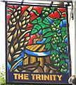
1
Sign for the Trinity, Bath
The name may refer to the Trinity Brewery which was absorbed by the West Country brewery and then in turn by Whitbreads.
Image: © Maigheach-gheal Taken: 18 Sep 2008
0.01 miles
2
Bath : Charles Street
Traffic lights and crossing looking toward Charles Street. The man at the front was running from one side to the other and is no posing in any way. There is also a hot air balloon.
Image: © Lewis Clarke Taken: 22 Oct 2008
0.01 miles
3
Ordnance Survey Cut Mark
This OS cut mark can be found on the wall of No17 Charles Street. It marks a point 27.125m above mean sea level.
Image: © Adrian Dust Taken: 3 Dec 2022
0.01 miles
4
Apex City of Bath
A swish four star city centre hotel has gone up on the site of the old Kingsmead House.
Image: © Neil Owen Taken: 28 Dec 2021
0.02 miles
5
You're having another Bath (47)
Box junction in Charles Street
Image: © Basher Eyre Taken: 4 Apr 2024
0.02 miles
6
You're having another Bath (46)
Looking from James Street West, across Charles Street and towards The Salvation Army
Image: © Basher Eyre Taken: 4 Apr 2024
0.02 miles
7
You're having another Bath (62)
Lulu Café, Hot Bath Street
Image: © Basher Eyre Taken: 4 Apr 2024
0.02 miles
8
Former station building, Bath Green Park
This was the main entrance building of the former Midland Railway station in Bath, which was also famously used by trains from the Somerset & Dorset Joint Railway. This building is now a "brasserie & bar", while the overall roof has become part of a supermarket car park (see Image and Image).
Image: © Richard Vince Taken: 19 Feb 2010
0.02 miles
9
Green Park Brasserie and Bar, Bath
The Green Park Brasserie occupies the old booking hall of Bath (Green Park) Railway Station, http://www.geograph.org.uk/photo/1770297 built by the Midland Railway in 1870 and used jointly with the Somerset and Dorset Railway from 1874. The station closed in 1966.
Image: © Jaggery Taken: 10 Dec 2012
0.02 miles
10
Kingsmead House, James Street, Bath
The almost(?) solitary incursion of 1960s slabs into Bath. By W.S. Frost of the Ministry of Public Building and Works (who was much more successful here Image]). Formerly Government offices, standing empty at the time, probably awaiting its own death knell. Immediately north is the Image
Image: © Stephen Richards Taken: 25 May 2012
0.03 miles
  • ...