IMAGES TAKEN NEAR TO
Barton Street, BATH, BA1 1HG
Introduction
This page details the photographs taken nearby to Barton Street, BA1 1HG by members of the Geograph project.
The Geograph project started in 2005 with the aim of publishing, organising and preserving representative images for every square kilometre of Great Britain, Ireland and the Isle of Man.

There are currently over 7.5m images from over14,400 individuals and you can help contribute to the project by visiting https://www.geograph.org.uk
Image Map
Images are licensed for reuse under creativecommons.org/licenses/by-sa/2.0
Notes
- Clicking on the map will re-center to the selected point.
- The higher the marker number, the further away the image location is from the centre of the postcode.
Image Listing (1916 Images Found)
Images are licensed for reuse under creativecommons.org/licenses/by-sa/2.0
Image
Details
Distance
1
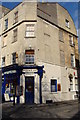
Are you a Harrington sort of person?
The Harrington Club on Harrington Place is one that salutes those who can drink and remain sociable.
Image: © Neil Owen
Taken: 28 Dec 2021
0.02 miles
2
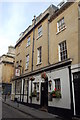
The Raven Inn, Bath
The Raven Inn, Queen Street, Bath
Image: © Gary Brothwell
Taken: 23 Sep 2010
0.02 miles
3
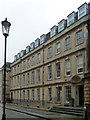
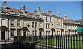
15-17 Trim Street, Bath
Three large former town houses of 1724, restored in 1897 and again in the C20th after bomb damage (when presumably the mansard roof and dormers were added). The windows have keystones linked to continuous platbands. The near doorcase has a good shell hood. Grade II listed.
Now offices.
Image: © Stephen Richards
Taken: 24 May 2012
0.02 miles
5
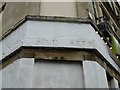
Old Boundary Marker by Barton Street, Bath Parish
Parish Boundary Marker by the UC road, in parish of Bath (Bath and North East Somerset District), Barton Street/Trim Street, at corner of Upper Borough Walls, on high fillet to right.
Surveyed.
Milestone Society National ID: SO_BHSMSPP02pb
Image: © Milestone Society
Taken: Unknown
0.02 miles
6
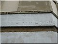
Old Boundary Marker by Barton Street, Bath Parish
Parish Boundary Marker by the UC road, in parish of Bath (Bath And North East Somerset District), Barton Street, at corner of Trim Street, on high fillet to left.
Surveyed
Milestone Society National ID: SO_BHSMSPP01pb
Image: © Milestone Society
Taken: Unknown
0.02 miles
7
14-21 Beauford Square, Bath
Modest two- or three-storey houses, built c1730 by John Strahan for John Hobbs, a Bristol sail-maker and timber merchant who developed the site. The splitting of several of the windows by a central mullion was apparently to avoid window tax. Grade II listed.
Image: © Stephen Richards
Taken: 25 May 2012
0.03 miles
8
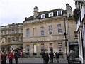
Bath - Beau Nash House - Now Strada Restaurant.
Image: © Roy Hughes
Taken: 26 Nov 2011
0.03 miles
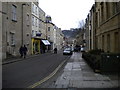
9
The Walrus and the Carpenter - and a road junction
This restaurant at the road junction between Barton Street and Harington Place.
Image: © Ruth Sharville
Taken: 1 Mar 2009
0.03 miles
10
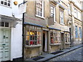
No. 11 Queen Street
The premises of Vintage and Rare Guitars in Bath http://www.vintageandrareguitars.com/
Image: © Chris Holifield
Taken: 22 Oct 2011
0.03 miles