IMAGES TAKEN NEAR TO
East Woodlands, FROME, BA11 5LY
Introduction
This page details the photographs taken nearby to BA11 5LY by members of the Geograph project.
The Geograph project started in 2005 with the aim of publishing, organising and preserving representative images for every square kilometre of Great Britain, Ireland and the Isle of Man.

There are currently over 7.5m images from over14,400 individuals and you can help contribute to the project by visiting https://www.geograph.org.uk
Image Map (Loading...)


Getting Data...Please wait
Leaflet Map data © OpenStreetMap
Images are licensed for reuse under creativecommons.org/licenses/by-sa/2.0
Notes
- Clicking on the map will re-center to the selected point.
- The higher the marker number, the further away the image location is from the centre of the postcode.
Image Listing (7 Images Found)
Images are licensed for reuse under creativecommons.org/licenses/by-sa/2.0
Image
Details
Distance
1
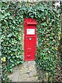
Victorian postbox, East Woodlands
Found in a wall very near the Horse and Groom public house.
Image: © Maigheach-gheal
Taken: 30 Jan 2009
0.00 miles
2
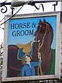
Sign for the Horse and Groom
A wild looking horse if you ask me!
Image: © Maigheach-gheal
Taken: 30 Jan 2009
0.01 miles
3
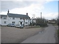
East Woodlands
A view looking northwest in the hamlet of East Woodlands, with the Horse and Groom public house on the left.
Image: © Phil Williams
Taken: 26 Feb 2006
0.01 miles
4
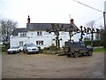
The Horse and Groom, East Woodlands
An interesting village pub.
Image: © Maigheach-gheal
Taken: 30 Jan 2009
0.02 miles
5
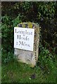
Old Milestone by East Woodlands Road, Selwood parish
Metal plate attached to stone post by the UC road, in parish of SELWOOD (MENDIP District), East Selwood village, East Woodlands Road, by Horse & Jockey Tollhouse, on grass lawn to right of tollhouse, on North side of road. Frome square iron plate, erected by the Frome turnpike trust in the 18th century.
Inscription reads:-
Longleat
Houſe
2 Miles.
Grade II listed.
List Entry Number: 1058068 https://historicengland.org.uk/listing/the-list/list-entry/1058068
Milestone Society National ID: SO_LLH02
Image: © Alan Rosevear
Taken: 1 Dec 2012
0.08 miles
6
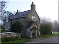
Old Toll House by East Woodlands Road, Selwood
Toll House in the parish of Selwood, 21, East Woodlands Road, at the junction with Feltham Lane.
Somerset HER.
HER number: 40876 https://www.heritagegateway.org.uk/Gateway/Results_Single.aspx?uid=40876&resourceID=100
Surveyed
Milestone Society National ID: SO.SEL03
Image: © Alan Rosevear
Taken: 1 Dec 2012
0.09 miles
7

Direction Sign - Signpost on the crossroads west of Cole Hill
Pyramid finial - 3 arms, 1 lost; Somerset SCC pyramid by the UC road, in parish of Selwood (Mendip District), west of Cole Hill on the east side of the crossroads of Shepherd's Lane and East Woodlands Road.
surveyed
Milestone Society National ID: SO_ST7944
Image: © Milestone Society
Taken: Unknown
0.22 miles