IMAGES TAKEN NEAR TO
East Woodlands, FROME, BA11 5LQ
Introduction
This page details the photographs taken nearby to BA11 5LQ by members of the Geograph project.
The Geograph project started in 2005 with the aim of publishing, organising and preserving representative images for every square kilometre of Great Britain, Ireland and the Isle of Man.

There are currently over 7.5m images from over14,400 individuals and you can help contribute to the project by visiting https://www.geograph.org.uk
Image Map (Loading...)


Getting Data...Please wait
Leaflet Map data © OpenStreetMap
Images are licensed for reuse under creativecommons.org/licenses/by-sa/2.0
Notes
- Clicking on the map will re-center to the selected point.
- The higher the marker number, the further away the image location is from the centre of the postcode.
Image Listing (9 Images Found)
Images are licensed for reuse under creativecommons.org/licenses/by-sa/2.0
Image
Details
Distance
1
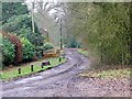
Byway, East Woodlands
The byway heads to Roddenbury Hill. It is right on the gridline.
Image: © Maigheach-gheal
Taken: 30 Jan 2009
0.03 miles
2
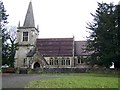
St Katherine's Church, East Woodlands
A pretty little church in the back of beyond. The church was built between 1712 to 1714.
Image: © Maigheach-gheal
Taken: 30 Jan 2009
0.04 miles
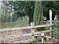
3
2010 : Lane junction at East Woodlands
The lane from the main part of the village divides here, to the right, in a few yards, we find New Church Farm, to the left the parish church and Lower Woods.
Image: © Maurice Pullin
Taken: 2 Aug 2010
0.04 miles
4
Footpath, East Woodlands
The footpath takes walkers to West Woodlands.
Image: © Maigheach-gheal
Taken: 30 Jan 2009
0.06 miles
5
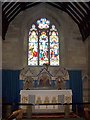
Interior, St Katherine's Church
The church built on the ridge west of Longleat Park, was mostly rebuilt by the architect John Loughborough Pearson in 1880.
Image: © Maigheach-gheal
Taken: 30 Jan 2009
0.06 miles
6
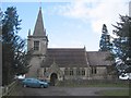
Church at East Woodlands
A view looking north to the church at East Woodlands.
Image: © Phil Williams
Taken: 25 Feb 2006
0.09 miles
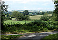
7
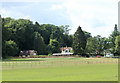
2010 : Field and paddock , East Woodlands
Seen from the bridleway leading into Lower Woods.
Image: © Maurice Pullin
Taken: 2 Aug 2010
0.13 miles
8
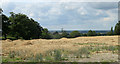
2010 : An ex- wheatfield, straw waiting to be gathered in
The farm vehicle is over the brow of the hill waiting for that pesky photographer to go.
You can just about see a bit of Frome in the distance left of centre.
Image: © Maurice Pullin
Taken: 2 Aug 2010
0.18 miles
9
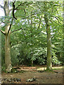
2010 : Beech trees on the edge of Lower Woods
Over time the detritus left on the ground will decay and improve the soil.
Image: © Maurice Pullin
Taken: 2 Aug 2010
0.21 miles