IMAGES TAKEN NEAR TO
Friggle Street, FROME, BA11 5LJ
Introduction
This page details the photographs taken nearby to BA11 5LJ by members of the Geograph project.
The Geograph project started in 2005 with the aim of publishing, organising and preserving representative images for every square kilometre of Great Britain, Ireland and the Isle of Man.

There are currently over 7.5m images from over14,400 individuals and you can help contribute to the project by visiting https://www.geograph.org.uk
Image Map
Images are licensed for reuse under creativecommons.org/licenses/by-sa/2.0
Notes
- Clicking on the map will re-center to the selected point.
- The higher the marker number, the further away the image location is from the centre of the postcode.
Image Listing (5 Images Found)
Images are licensed for reuse under creativecommons.org/licenses/by-sa/2.0
Image
Details
Distance
1
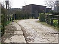
Footpath, Friggle Street
The footpath passes through the farmyard of Bollow Hill Farm on its way to Bollow Farm.
Image: © Maigheach-gheal
Taken: 16 Mar 2009
0.03 miles
2
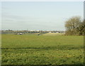
2008 : Pasture near Elliots Green
Looking north west to the outskirts of Frome.
Image: © Maurice Pullin
Taken: 9 Dec 2008
0.05 miles
3
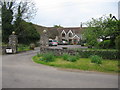
Friggle Towers
A view looking west across Friggle Street towards Friggle Towers.
Image: © Phil Williams
Taken: 7 May 2006
0.07 miles
4
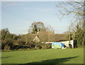
2008 : Friggle Towers from the south
Just off Friggle Street.
Image: © Maurice Pullin
Taken: 9 Dec 2008
0.08 miles
5
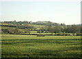
2008 : Pasture on Friggle Street
Near Elliots Green.
Cley Hill is on the skyline Image with Lane End on the hill between
Image: © Maurice Pullin
Taken: 9 Dec 2008
0.12 miles