IMAGES TAKEN NEAR TO
Bunns Lane, FROME, BA11 5ES
Introduction
This page details the photographs taken nearby to Bunns Lane, BA11 5ES by members of the Geograph project.
The Geograph project started in 2005 with the aim of publishing, organising and preserving representative images for every square kilometre of Great Britain, Ireland and the Isle of Man.

There are currently over 7.5m images from over14,400 individuals and you can help contribute to the project by visiting https://www.geograph.org.uk
Image Map (Loading...)


Getting Data...Please wait
Leaflet Map data © OpenStreetMap
Images are licensed for reuse under creativecommons.org/licenses/by-sa/2.0
Notes
- Clicking on the map will re-center to the selected point.
- The higher the marker number, the further away the image location is from the centre of the postcode.
Image Listing (2 Images Found)
Images are licensed for reuse under creativecommons.org/licenses/by-sa/2.0
Image
Details
Distance
1
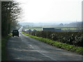
2009 : West on Bunns Lane
With a view of Broadway Farm.
The chimney to the right is associated with an old brickyard, probably now closed.
Image: © Maurice Pullin
Taken: 20 Mar 2009
0.05 miles
2
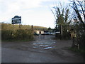
Ransomes scrapyard
A view looking east across Bunns Lane towards the entrance to Ransomes scrapyard.
Image: © Phil Williams
Taken: 14 Jan 2007
0.13 miles