IMAGES TAKEN NEAR TO
Blatchbridge, FROME, BA11 5EG
Introduction
This page details the photographs taken nearby to BA11 5EG by members of the Geograph project.
The Geograph project started in 2005 with the aim of publishing, organising and preserving representative images for every square kilometre of Great Britain, Ireland and the Isle of Man.

There are currently over 7.5m images from over14,400 individuals and you can help contribute to the project by visiting https://www.geograph.org.uk
Image Map
Images are licensed for reuse under creativecommons.org/licenses/by-sa/2.0
Notes
- Clicking on the map will re-center to the selected point.
- The higher the marker number, the further away the image location is from the centre of the postcode.
Image Listing (5 Images Found)
Images are licensed for reuse under creativecommons.org/licenses/by-sa/2.0
Image
Details
Distance
1
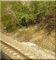
View of the railway cutting from a stationary train, south of Blatchbridge
Image: © Rob Purvis
Taken: 30 Apr 2016
0.08 miles
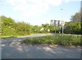
3
Countryside near Tytherington
View south west from the A361 between Tytherington and Blatchbridge.
Image: © Nigel Mykura
Taken: 2 May 2009
0.19 miles
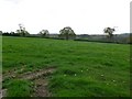
4
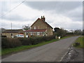
Windwistle Cottage
A view looking southeast along the lane leading to East Woodlands, showing Windwistle Cottage on the left.
Image: © Phil Williams
Taken: 12 Mar 2006
0.22 miles