IMAGES TAKEN NEAR TO
Marston Park, FROME, BA11 5BS
Introduction
This page details the photographs taken nearby to Marston Park, BA11 5BS by members of the Geograph project.
The Geograph project started in 2005 with the aim of publishing, organising and preserving representative images for every square kilometre of Great Britain, Ireland and the Isle of Man.

There are currently over 7.5m images from over14,400 individuals and you can help contribute to the project by visiting https://www.geograph.org.uk
Image Map (Loading...)


Getting Data...Please wait
Leaflet Map data © OpenStreetMap
Images are licensed for reuse under creativecommons.org/licenses/by-sa/2.0
Notes
- Clicking on the map will re-center to the selected point.
- The higher the marker number, the further away the image location is from the centre of the postcode.
Image Listing (5 Images Found)
Images are licensed for reuse under creativecommons.org/licenses/by-sa/2.0
Image
Details
Distance
1
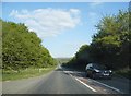
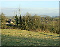
Somerset Farmland
A view looking east over farmland from Bulls Quarr. The A361 Frome bypass can be seen in the middle distance with Cley Hill on the horizon at centre left, and Longleat Forest at centre right,
Image: © Phil Williams
Taken: 26 Feb 2006
0.06 miles
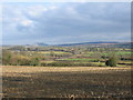
3
2009 : Entrance to Marston Park
Looking east over farmland south of Frome. The A361 is behind the camera position. Cley Hill Image is at centre horizon. A recent fall of snow remains on the ground.
Image: © Maurice Pullin
Taken: 10 Feb 2009
0.17 miles
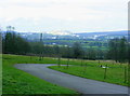
4
2009 : East from Little Keyford Lane
Showing a corner of some English field near the Frome bypass.
Sandy's Hill Farm is almost hidden by the hedge to the left.
Cley Hill Image stands out to the right.
Image: © Maurice Pullin
Taken: 13 Jan 2009
0.21 miles