IMAGES TAKEN NEAR TO
Leighton, FROME, BA11 4PW
Introduction
This page details the photographs taken nearby to BA11 4PW by members of the Geograph project.
The Geograph project started in 2005 with the aim of publishing, organising and preserving representative images for every square kilometre of Great Britain, Ireland and the Isle of Man.

There are currently over 7.5m images from over14,400 individuals and you can help contribute to the project by visiting https://www.geograph.org.uk
Image Map (Loading...)


Getting Data...Please wait
Leaflet Map data © OpenStreetMap
Images are licensed for reuse under creativecommons.org/licenses/by-sa/2.0
Notes
- Clicking on the map will re-center to the selected point.
- The higher the marker number, the further away the image location is from the centre of the postcode.
Image Listing (10 Images Found)
Images are licensed for reuse under creativecommons.org/licenses/by-sa/2.0
Image
Details
Distance
3
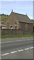
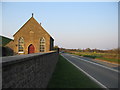
Former chapel, Leighton
This humble and grimy building with a tin roof now appears to be absorbed into the farmyard buildings of Chapel Farm. Once a Primitive Methodist chapel, it is dated 1863, so the roof is not original.
Image: © Robin Webster
Taken: 2 Apr 2017
0.02 miles
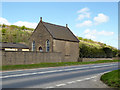
4
Approaching Leighton
A view looking to the northwest towards the A361 at Leighton. The building on the right is a now disused chapel. The large mound in the background is part of the overburden removed from the extension of the Torr Works quarry, prior to quarrying operations.
Image: © Phil Williams
Taken: 1 Apr 2007
0.02 miles
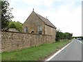
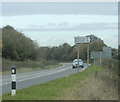
5
Leighton Chapel
A view looking to the northeast along the A361 towards Leighton Chapel. As far as I am aware, the building is no longer used for religious purposes.
Image: © Phil Williams
Taken: 1 Apr 2007
0.03 miles
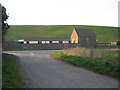
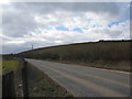
6
2009 : A361 heading east, half a mile from Leighton
A minor road heads south at this point taking a different route to Batcombe.
Image: © Maurice Pullin
Taken: 26 Oct 2009
0.23 miles
7
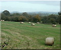
2009 : Field with straw bales off the A361
West of Leighton.
Cley Hill is to the left about 10 miles over. Image
Image: © Maurice Pullin
Taken: 26 Oct 2009
0.23 miles
8
A361 at Stearts Lane
A view looking west along the A361 from opposite the point at which it is joined by Stearts Lane. The regular shaped hill in the background is a recent addition to the landscape, being composed of the overburden removed for the extension to Merehead quarry. Some of the landscaping being carried out can be seen at right, with fresh soil exposed at left.
Image: © Phil Williams
Taken: 5 Mar 2006
0.25 miles
9
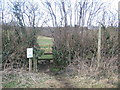
Footpath diversion
The sign adjacent to this stile, at the start of the footpath from the A361 to Heale Ladder, requests walkers to follow the new signed routes. These are necessary due to the creation of a new hill by the overburden removed from the Merehead quarry extension.
Image: © Phil Williams
Taken: 5 Mar 2006
0.25 miles
10
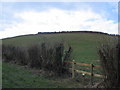
A new hill!
The hillside behind the stile is a relatively new addition to the landscape, being created by the overburden removed from the extension of Merehead quarry. It will eventually be replaced when the quarry workings are finished and the landscape returned to its former condition.
Image: © Phil Williams
Taken: 5 Mar 2006
0.25 miles