IMAGES TAKEN NEAR TO
Cloford, FROME, BA11 4PF
Introduction
This page details the photographs taken nearby to BA11 4PF by members of the Geograph project.
The Geograph project started in 2005 with the aim of publishing, organising and preserving representative images for every square kilometre of Great Britain, Ireland and the Isle of Man.

There are currently over 7.5m images from over14,400 individuals and you can help contribute to the project by visiting https://www.geograph.org.uk
Image Map
Images are licensed for reuse under creativecommons.org/licenses/by-sa/2.0
Notes
- Clicking on the map will re-center to the selected point.
- The higher the marker number, the further away the image location is from the centre of the postcode.
Image Listing (11 Images Found)
Images are licensed for reuse under creativecommons.org/licenses/by-sa/2.0
Image
Details
Distance
1
Cloford Common
A view looking to the south at Cloford Common.
Image: © Phil Williams
Taken: 4 Jul 2007
0.01 miles
2
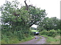
Footpath to Cloford Common Farm.
A view looking to the northeast towards the public footpath to Cloford Common Farm, blocked by the farm trailer.
Image: © Phil Williams
Taken: 4 Jul 2007
0.05 miles
3
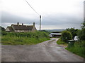
Cloford Common Farm
A view looking to the east towards the public footpath at the entrance to Cloford Common Farm.
Image: © Phil Williams
Taken: 4 Jul 2007
0.06 miles
4
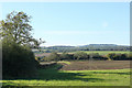
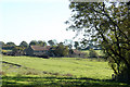
2010 : Looking west at Cloford Common
Field and a well trimmed hedgerow, the small blip on the horizon is Cranmore Tower Image
Image: © Maurice Pullin
Taken: 25 Oct 2010
0.09 miles
5
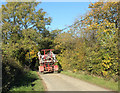
2010 : Farm machinery at Cloford Common
Unidentified (so far).
Michael Trolove, a fellow geographer, advises:
"Spraying crops, horticultural or agricultural is nearly a year round activity.
October spraying Winter Wheat crops will include grass weed control, pre and post crop emergence, an insecticide to target aphids that spread the Barley yellow dwarf virus ( infects all cereals)
A broad leaved weed spray and possibly a fungicide to prevent disease build up.
Oil seed rape will have a similar regime using different chemistry and that's October. November sprays, mostly grass weed control in OSR
December and January, not much crop spraying done."
Image: © Maurice Pullin
Taken: 25 Oct 2010
0.11 miles
6
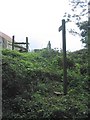
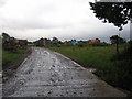
Footpath at Cloford Common
A view looking to the northwest towards a public footpath at Cloford Common. Although a stile is provided at the fence, to reach it involves a scramble up the overgrown bank.
Image: © Phil Williams
Taken: 4 Jul 2007
0.13 miles
7
2010 : Postlebury Farm, Cloford Common
Image: © Maurice Pullin
Taken: 25 Oct 2010
0.14 miles
8
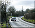
2009 : A359 looking south
from the by-road to Cloford Common. The sign post points to Cloford about a quarter mile to the right.
The A359 forms a useful link between West Wiltshire and the south coast and is very busy in summer months especially at weekends.
Image: © Maurice Pullin
Taken: 2 Mar 2009
0.19 miles
9
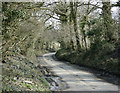
2009 : Lane to Cloford Common
I could hardly leave the A359 without giving you a glimpse of this lane as it has been mentioned so often.
Nothing prepossessing about it but pleasant for all that.
Image: © Maurice Pullin
Taken: 2 Mar 2009
0.20 miles
10
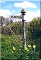
Direction Sign - Signpost on the A359 in Wanstrow parish
Pyramid finial - 1 arm; Somerset SCC pyramid by the A359, in parish of Wanstrow (Mendip District), on the southeast side of the T junction of the A359 and the lane to Cloford village.
surveyed
Milestone Society National ID: SO_ST7243
Image: © Milestone Society
Taken: Unknown
0.20 miles