IMAGES TAKEN NEAR TO
Whatley, FROME, BA11 3LB
Introduction
This page details the photographs taken nearby to BA11 3LB by members of the Geograph project.
The Geograph project started in 2005 with the aim of publishing, organising and preserving representative images for every square kilometre of Great Britain, Ireland and the Isle of Man.

There are currently over 7.5m images from over14,400 individuals and you can help contribute to the project by visiting https://www.geograph.org.uk
Image Map (Loading...)


Getting Data...Please wait
Leaflet Map data © OpenStreetMap
Images are licensed for reuse under creativecommons.org/licenses/by-sa/2.0
Notes
- Clicking on the map will re-center to the selected point.
- The higher the marker number, the further away the image location is from the centre of the postcode.
Image Listing (3 Images Found)
Images are licensed for reuse under creativecommons.org/licenses/by-sa/2.0
Image
Details
Distance
1
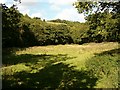
Mendip Way near Railford Bridge
The Mendip Way crosses this field into the woods at the corner opposite.
Image: © Patrick Mackie
Taken: 27 Aug 2006
0.18 miles
2
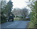
2009 : Minor road entering Chantry from the east
Coming from Whatley.
Little Acre Farm is on the right and squeezes in between the road and Whatley Quarry about 300 yards to the north.
Image: © Maurice Pullin
Taken: 15 Nov 2009
0.23 miles
3

2008 : The road to Frome leaving Chantry
Whatley limestone quarry is just a few hundred yards to the left.
Image: © Maurice Pullin
Taken: 9 Oct 2008
0.24 miles