IMAGES TAKEN NEAR TO
Sunny Hill, BRUTON, BA10 0NN
Introduction
This page details the photographs taken nearby to BA10 0NN by members of the Geograph project.
The Geograph project started in 2005 with the aim of publishing, organising and preserving representative images for every square kilometre of Great Britain, Ireland and the Isle of Man.

There are currently over 7.5m images from over14,400 individuals and you can help contribute to the project by visiting https://www.geograph.org.uk
Image Map (Loading...)


Getting Data...Please wait
Leaflet Map data © OpenStreetMap
Images are licensed for reuse under creativecommons.org/licenses/by-sa/2.0
Notes
- Clicking on the map will re-center to the selected point.
- The higher the marker number, the further away the image location is from the centre of the postcode.
Image Listing (8 Images Found)
Images are licensed for reuse under creativecommons.org/licenses/by-sa/2.0
Image
Details
Distance

2
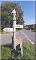
Old Direction Sign - Signpost by Sunny Hill, Lusty
Pyramid finial - 2 arms; Somerset SCC pyramid by the UC road, in parish of Bruton (South Somerset District), Sunny Hill, junction with Cole Road, Lusty.
Surveyed
Milestone Society National ID: SO_ST6733C
Image: © Milestone Society
Taken: Unknown
0.06 miles
4
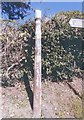
Old Direction Sign - Signpost by Sunny Hill, Pitcombe parish
Lost finial - lost arms; Somerset SCC pyramid by the UC road, in parish of Pitcombe (South Somerset District), Sunny Hill, lane to Cole, opposite school entrance.
Surveyed
Milestone Society National ID: SO_ST6733B
Image: © Milestone Society
Taken: Unknown
0.13 miles
5

Old Direction Sign - Signpost by the A359, Strutter's Hill
Lost finial - 1 arm; Somerset SCC pyramid by the UC road, in parish of Pitcombe (South Somerset District), Strutter's Hill junction with Pitcombe Rock, the lane to Pitcombe.
Surveyed
Milestone Society National ID: SO_ST6733A
Image: © Milestone Society
Taken: Unknown
0.21 miles
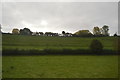
7

Remains of railway bridge near former Cole station
Railway bridge just south of former Cole station on disused Somerset & Dorset Joint Railway. https://en.wikipedia.org/wiki/Somerset_and_Dorset_Joint_Railway
Image: © Vieve Forward
Taken: 8 Sep 2017
0.24 miles
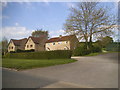
8

Cole Station
Cole station building, now converted to a dwelling, on former Somerset & Dorset Joint Railway. https://en.wikipedia.org/wiki/Somerset_and_Dorset_Joint_Railway
Image: © Vieve Forward
Taken: 8 Sep 2017
0.25 miles