
IMAGES TAKEN NEAR TO
North Brewham, BRUTON, BA10 0JF
Introduction
This page details the photographs taken nearby to BA10 0JF by members of the Geograph project.
The Geograph project started in 2005 with the aim of publishing, organising and preserving representative images for every square kilometre of Great Britain, Ireland and the Isle of Man.

There are currently over 7.5m images from over14,400 individuals and you can help contribute to the project by visiting https://www.geograph.org.uk
Image Map
Images are licensed for reuse under creativecommons.org/licenses/by-sa/2.0
Notes
- Clicking on the map will re-center to the selected point.
- The higher the marker number, the further away the image location is from the centre of the postcode.
Image Listing (10 Images Found)
Images are licensed for reuse under creativecommons.org/licenses/by-sa/2.0
Image
Details
Distance
1
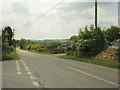
2009 : Brewham Road at North Brewham
The turning to the left descends The Hill to South Brewham. About 2 miles along this road you come to Bruton.
Image: © Maurice Pullin
Taken: 29 May 2009
0.04 miles
2
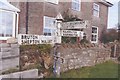
Old Direction Sign - Signpost by North Brewham
Pyramid finial - 3 arms; Somerset SCC pyramid by the UC road, in parish of Brewham (South Somerset District), James's Hill junction with Tile Hill, North of village.
Surveyed
Milestone Society National ID: SO_ST7236.
Image: © Milestone Society
Taken: Unknown
0.06 miles
3
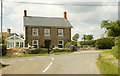
2009 : Cottage at the top of The Hill, North Brewham
Left for Bruton and Shepton Mallet, right for Kilmington and Warminster, turn round and go down The Hill for South Brewham.
It was the blue clematis that attracted me.
Image: © Maurice Pullin
Taken: 29 May 2009
0.07 miles
4
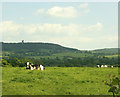
2009 : Cows and pasture, North Brewham
King Alfred's Tower is on the hill to the left. Image
Image: © Maurice Pullin
Taken: 29 May 2009
0.12 miles
5
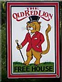
Sign for the Old Red Lion
The Red Lion is the badge of John of Gaunt, Duke of Lancaster, the fourth son of Edward III. He lived from 1340-1399 and the Red Lion began appearing as a pub sign during the following century. Here the lion is somewhat differently portrayed.
Image: © Maigheach-gheal
Taken: 6 Sep 2009
0.20 miles
6
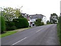
The Old Red Lion, North Brewham
The inn was originally built as a farmhouse.
Image: © Maigheach-gheal
Taken: 6 Sep 2009
0.20 miles
7
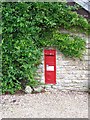
Postbox, North Brewham
A Victorian postbox found near the Old Red Lion Inn.
Image: © Maigheach-gheal
Taken: 6 Sep 2009
0.21 miles
8
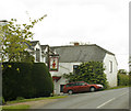
2009 : The Old Red Lion, North Brewham
On James's Hill.
You escape from Longleat, off to Bath for a tidy-up, new hat, coat, walking cane and there you are, a dandy lion.
Not much on the web about this good looking hostelry, suggests the landlord is doing well enough without it.
Image: © Maurice Pullin
Taken: 29 May 2009
0.21 miles
9

Old Direction Sign - Signpost by James's Hill, Brewham parish
Pyramid finial - 3 arms; Somerset SCC pyramid by the UC road, in parish of Brewham (South Somerset District), James's Hill junction with Sock's Lane, near pub, North of village.
Surveyed
Milestone Society National ID: SO_ST7237
Image: © Milestone Society
Taken: Unknown
0.24 miles
10
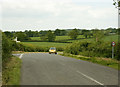
2009 : On James's Hill near North Brewham
Sock's Lane turns off to the left and becomes Hassock's Lane when it has crossed the railway.
Image: © Maurice Pullin
Taken: 29 May 2009
0.25 miles