
IMAGES TAKEN NEAR TO
High Street, BRUTON, BA10 0AH
Introduction
This page details the photographs taken nearby to High Street, BA10 0AH by members of the Geograph project.
The Geograph project started in 2005 with the aim of publishing, organising and preserving representative images for every square kilometre of Great Britain, Ireland and the Isle of Man.

There are currently over 7.5m images from over14,400 individuals and you can help contribute to the project by visiting https://www.geograph.org.uk
Image Map
Images are licensed for reuse under creativecommons.org/licenses/by-sa/2.0
Notes
- Clicking on the map will re-center to the selected point.
- The higher the marker number, the further away the image location is from the centre of the postcode.
Image Listing (229 Images Found)
Images are licensed for reuse under creativecommons.org/licenses/by-sa/2.0
Image
Details
Distance
1
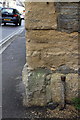
Benchmark on #30 High Street
Ordnance Survey cut mark benchmark described on the Bench Mark Database at http://www.bench-marks.org.uk/bm45517
Image: © Roger Templeman
Taken: 24 Sep 2012
0.01 miles
2
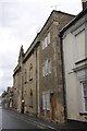
#30 High Street
Listed Grade II described as:
Small town house, in row. Early C18. Local stone rubble with Doulting stone dressings; possibly flat roof hidden by parapets; brick end chimney stack. 3 storeys, one bay. Plinth, large ashlar quoins, band course below shallow parapet which has angled upsweeps each side. Ground floor re-arranged, with 2 single-light casements in plain surrounds to left of late C20 part glazed door - door originally central with smaller sidelights; to first floor Venetian window with small-pane casements in plain surround; above 3 single-light casements in linked surround. Interior much altered at ground floor level.
There is an OS benchmark Image on the side jut face of the building which is next to a (former?) church on the far side.
Image: © Roger Templeman
Taken: 24 Sep 2012
0.01 miles
3
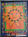
Sign for the Sun Inn, Bruton
The early uses of 'Sun' as a tavern sign made use of its simple visual form. It was painted as a circle with a few rays around it, and often filled in with eyes, a nose and a mouth.
Image: © Maigheach-gheal
Taken: 22 Jan 2008
0.01 miles
4

The Sun Inn, Bruton
Until 1801 or later the court met at the Sun Inn in May and October or November.
Image: © Maigheach-gheal
Taken: 22 Jan 2008
0.02 miles
5

Priory House, Bruton
Now part of King's School.
Image: © Maigheach-gheal
Taken: 22 Jan 2008
0.02 miles
6
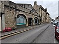
Bruton : High Street A359
Looking along Bruton High Street.
Image: © Lewis Clarke
Taken: 30 Jan 2024
0.03 miles
7
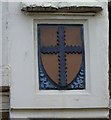
Architectural detail, Priory House, Bruton
Image: © Maigheach-gheal
Taken: 22 Jan 2008
0.03 miles
8

Bruton backing onto the River
Taken by the old packhorse bridge over the Brue. The town backs onto the river on both sides.
The Leland Trail and MacMillan Way long distance footpaths choose to stay beside the river, rather than visit the busy main street.
Image: © Chris Heaton
Taken: 2 Feb 2022
0.03 miles
9

High Street bikers, Bruton, Somerset
Motorcyclists on one-way High Street in September 2022.
Image: © Jaggery
Taken: 17 Sep 2022
0.04 miles
10
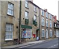
Bruton Post Office
The post office has fine Georgian windows.
Image: © Maigheach-gheal
Taken: 22 Jan 2008
0.04 miles