IMAGES TAKEN NEAR TO
Padbury Close, REDDITCH, B98 9AG
Introduction
This page details the photographs taken nearby to Padbury Close, B98 9AG by members of the Geograph project.
The Geograph project started in 2005 with the aim of publishing, organising and preserving representative images for every square kilometre of Great Britain, Ireland and the Isle of Man.

There are currently over 7.5m images from over14,400 individuals and you can help contribute to the project by visiting https://www.geograph.org.uk
Image Map
Images are licensed for reuse under creativecommons.org/licenses/by-sa/2.0
Notes
- Clicking on the map will re-center to the selected point.
- The higher the marker number, the further away the image location is from the centre of the postcode.
Image Listing (6 Images Found)
Images are licensed for reuse under creativecommons.org/licenses/by-sa/2.0
Image
Details
Distance
1
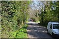
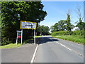
The old line of Icknield Street, Church Hill, Redditch
Icknield or Ryknild Street was a Roman road running roughly north-south through the Midlands http://en.wikipedia.org/wiki/Icknield_Street It can be followed through Redditch.
Image: © Robin Stott
Taken: 1 May 2013
0.16 miles
4
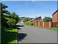
Stoke Lane, Redditch
In the suburb of Church Hill.
Image: © JThomas
Taken: 22 Jun 2019
0.23 miles
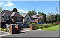
6
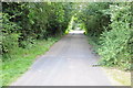
Ryknild Street
The Roman Road, Ryknild Street, passing through a housing estate in the suburbs of Redditch.
Image: © Philip Halling
Taken: 28 Jul 2012
0.23 miles