IMAGES TAKEN NEAR TO
Seven Acres Lane, REDDITCH, B98 8QX
Introduction
This page details the photographs taken nearby to Seven Acres Lane, B98 8QX by members of the Geograph project.
The Geograph project started in 2005 with the aim of publishing, organising and preserving representative images for every square kilometre of Great Britain, Ireland and the Isle of Man.

There are currently over 7.5m images from over14,400 individuals and you can help contribute to the project by visiting https://www.geograph.org.uk
Image Map
Images are licensed for reuse under creativecommons.org/licenses/by-sa/2.0
Notes
- Clicking on the map will re-center to the selected point.
- The higher the marker number, the further away the image location is from the centre of the postcode.
Image Listing (8 Images Found)
Images are licensed for reuse under creativecommons.org/licenses/by-sa/2.0
Image
Details
Distance
1
Book and Candle
The public house in the centre of the Church Hill district of Redditch. The pub garden seems to be largely surrounded by high panel fencing.
Image: © David Stowell
Taken: 22 Apr 2006
0.08 miles
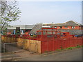
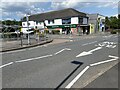
2
Church Hill centre, Redditch
The new town of Redditch was built as a series of distinct districts each with their own centre hub. These are the shops at the centre of the Church Hill district. As can be seen they are fitted with heavy shutters as these areas seem to attract unwelcome attention outside of trading hours!
Image: © David Stowell
Taken: 22 Apr 2006
0.12 miles
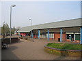
3
Gordon Anstis House, Redditch
The YMCA building in Church Hill, Redditch.
Image: © David Stowell
Taken: 22 Apr 2006
0.12 miles
4
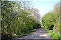
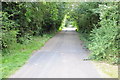
Marlfield Lane, Church Hill, Redditch
The evocatively-named Marlfield Lane is a Worcestershire country lane that was incorporated into the New Town as a broad footpath linking residential closes in the Church Hill district. Parallel to it for some distance is Church Hill Way, a dedicated bus route.
Image: © Robin Stott
Taken: 1 May 2013
0.14 miles
5
Ryknild Street
The Roman Road, Ryknild Street, passing through a housing estate in the suburbs of Redditch.
Image: © Philip Halling
Taken: 28 Jul 2012
0.18 miles
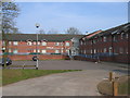
6
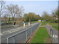
Busway, Church Hill
The new town districts of Redditch are linked by a network of bus-only roadways, sort of a poor man's tramway system, to provide traffic immune public transport around the town.
Image: © David Stowell
Taken: 22 Apr 2006
0.19 miles
7
Morrisons in Church Hill Redditch
The Morrisons Daily small supermarket in the Church Hill district of Redditch. In the foreground is the "bus-only" Church Hill Way, a feature in several Redditch districts.
Image: © Mike Dodman
Taken: 23 Jul 2024
0.20 miles
8
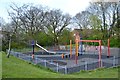
Play area in open space off Upper Field and Oldbury Closes, Church Hill, Redditch
The Worcestershire Arden landscape is still present in this district of the New Town.
Image: © Robin Stott
Taken: 1 May 2013
0.25 miles