1
Shops, Dowler's Hill Crescent, Greenlands, Redditch
Redditch districts were intended to be fairly self-contained, each with its own local shops. But with a number of big supermarkets in the town these small shops show signs of losing custom. Postbox (left) B98 141.
Image: © Robin Stott
Taken: 18 Feb 2013
0.05 miles
2
Sheldon Road, Greenlands, Redditch
From beside the hall attached to St Joseph's Church the view is across the Park Farm industrial estate to the hills of west Warwickshire.
Image: © Robin Stott
Taken: 18 Feb 2013
0.05 miles
3
St Joseph's Church, Greenlands Avenue, Redditch B98
The Greenlands estate was the first to be developed by the Redditch Development Corporation, following the designation of the New Town in 1964. Plans for Greenlands had been drawn up in the 1950s by Redditch Council. It was completed in the early 1970s though this church is more recent. The view is of the back of the church from Greenlands Avenue.
Image: © Robin Stott
Taken: 18 Feb 2013
0.05 miles
4
Greenlands Avenue, Greenlands, Redditch
Round the corner from
Image the road goes from gentle level curve to straight and startlingly steep.
Image: © Robin Stott
Taken: 18 Feb 2013
0.06 miles
5
Wharrington Hill, Greenlands, Redditch
Away from the valley of the River Arrow, Redditch is surprisingly hilly.
Image: © Robin Stott
Taken: 18 Feb 2013
0.09 miles
6
Greenlands Avenue, Greenlands, Redditch
A mixture of house types in this older part of the New Town.
Image: © Robin Stott
Taken: 18 Feb 2013
0.10 miles
7
Studley Road
Studley Road in Redditch.
Image: © Philip Halling
Taken: 11 Apr 2017
0.17 miles
8
Bus shelter, Studley Road
Looking south east across Studley Road towards a bus shelter with artwork on the front. Note as well the solar panel on the right, and the large litter bin on the left.
Image: © David P Howard
Taken: 10 Apr 2013
0.18 miles
9
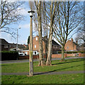
Highway land, Auxerre Avenue, Greenlands, Redditch
Poplars and maples were among the fast-growing trees used in the landscaping of the New Town; many are now mature. Beside the footpath to the bus stop in Studley Road, the not-inelegant lighting column is number 9346.
Image: © Robin Stott
Taken: 18 Feb 2013
0.19 miles
10
Bus shelter, Throckmorton Road, Greenlands, Redditch
Redditch has these appealing bespoke bus shelters. A credit on one of the panels explains: "This mural celebrates ‘Industry in Redditch’ and was created by New College graphic design student Noel Campbell working with the Redditch Community Safety Partnership." Being translucent, the colours glow and, on a practical security level, would reveal anyone hiding in or behind the shelter. Another view is
Image
In the background is Throckmorton Close. Throckmorton is the name of the family that occupied Coughton Court for centuries
Image
Image: © Robin Stott
Taken: 18 Feb 2013
0.19 miles


