IMAGES TAKEN NEAR TO
Harpswell Avenue, REDDITCH, B98 7GD
Introduction
This page details the photographs taken nearby to Harpswell Avenue, B98 7GD by members of the Geograph project.
The Geograph project started in 2005 with the aim of publishing, organising and preserving representative images for every square kilometre of Great Britain, Ireland and the Isle of Man.

There are currently over 7.5m images from over14,400 individuals and you can help contribute to the project by visiting https://www.geograph.org.uk
Image Map
Images are licensed for reuse under creativecommons.org/licenses/by-sa/2.0
Notes
- Clicking on the map will re-center to the selected point.
- The higher the marker number, the further away the image location is from the centre of the postcode.
Image Listing (20 Images Found)
Images are licensed for reuse under creativecommons.org/licenses/by-sa/2.0
Image
Details
Distance
1
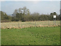
Site of Dingleside Middle School, Woodrow North, Redditch
No buildings can be seen. Current satellite imagery hasn't caught up: it shows the school buildings and playground where the belt of scrub is in the photo. The pale unmanaged grass beyond the fence may have been a playing field. The school was closed on 31 August 2008; the inference from websites is that the county closed the school following an adverse Ofsted report. The sign on the right reads: Worcestershire County Council. Notice is hereby given that action will be taken against any person who enters this land without prior consent or permission by the County Council.
Image: © Robin Stott
Taken: 18 Feb 2013
0.01 miles
2
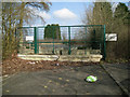
Former access to Dingleside Middle School, Woodrow North, Redditch
No buildings can be seen. Current satellite imagery hasn't caught up: it shows the school buildings and playground. The school was closed on 31 August 2008; the inference from websites is that the county closed the school following an adverse Ofsted report. Speculating, the obstructions to entering the site here may be to prevent occupation by travellers.
Image: © Robin Stott
Taken: 18 Feb 2013
0.04 miles
3
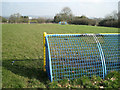
Kickabout above Highland Way, Greenlands, Redditch
As well as the goal mouths there's a basketball post and a smaller goalmouth for a few players.
Image: © Robin Stott
Taken: 18 Feb 2013
0.08 miles
4
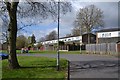
Rear of houses, Eckington Close, Woodrow, Redditch
The road in the foreground leads to Woodrow Centre, where the district's shops, services and buses may be accessed.
Image: © Robin Stott
Taken: 29 Apr 2013
0.14 miles
5
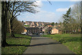
Shared path by Woodrow North, Redditch B98
The north end of Woodrow North turns sharply north to meet Auxerre Avenue. The Greenlands estate climbs the opposite hillside.
Image: © Robin Stott
Taken: 18 Feb 2013
0.14 miles
6
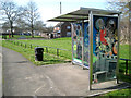
Bus shelter, Throckmorton Road, Greenlands, Redditch
Redditch has these appealing bespoke bus shelters. A credit on one of the panels explains: "This mural celebrates ‘Industry in Redditch’ and was created by New College graphic design student Noel Campbell working with the Redditch Community Safety Partnership." Being translucent, the colours glow and, on a practical security level, would reveal anyone hiding in or behind the shelter. Another view is Image
In the background is Throckmorton Close. Throckmorton is the name of the family that occupied Coughton Court for centuries Image
Image: © Robin Stott
Taken: 18 Feb 2013
0.15 miles
7
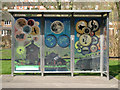
Bus shelter, Throckmorton Road, Greenlands, Redditch
Redditch has these appealing bespoke bus shelters. A credit on one of the panels explains: "This mural celebrates ‘Industry in Redditch’ and was created by New College graphic design student Noel Campbell working with the Redditch Community Safety Partnership." Being translucent, the colours glow and, on a practical security level, would reveal anyone hiding in or behind the shelter. Another view is Image
In the background is Throckmorton Close. Throckmorton is the name of the family that occupied Coughton Court for centuries Image
Image: © Robin Stott
Taken: 18 Feb 2013
0.15 miles
8
First floor of houses in Fladbury Close, Woodrow, Redditch
The ground falls away to the east of Woodrow North, towards the Arrow valley. Beyond the houses are the level roofs of factory units in the Park Farm industrial estate.
Image: © Robin Stott
Taken: 18 Feb 2013
0.16 miles
9
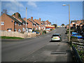
Wharrington Hill, Greenlands, Redditch
Away from the valley of the River Arrow, Redditch is surprisingly hilly.
Image: © Robin Stott
Taken: 18 Feb 2013
0.18 miles
10
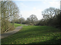
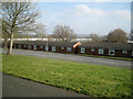
Open space beside Woodrow North, Greenlands, Redditch
Characteristic informal open space: grass, wide shared paths, street lighting. Retained hedgerow oaks, right, contrast with fast-growing species (ash in this case), left, planted during the development of the new town. Woodrow North, a distributor road, runs below the hedgerow.
Image: © Robin Stott
Taken: 18 Feb 2013
0.18 miles