IMAGES TAKEN NEAR TO
Oversley Close, REDDITCH, B97 6GW
Introduction
This page details the photographs taken nearby to Oversley Close, B97 6GW by members of the Geograph project.
The Geograph project started in 2005 with the aim of publishing, organising and preserving representative images for every square kilometre of Great Britain, Ireland and the Isle of Man.

There are currently over 7.5m images from over14,400 individuals and you can help contribute to the project by visiting https://www.geograph.org.uk
Image Map
Images are licensed for reuse under creativecommons.org/licenses/by-sa/2.0
Notes
- Clicking on the map will re-center to the selected point.
- The higher the marker number, the further away the image location is from the centre of the postcode.
Image Listing (5 Images Found)
Images are licensed for reuse under creativecommons.org/licenses/by-sa/2.0
Image
Details
Distance
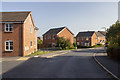
2

New estate Redditch
In the area below the derelict Lowan's Hill Farm and overlooking Enfield and the large Mettis Aerospace works.
Image: © Chris Allen
Taken: 23 Dec 2014
0.11 miles
4
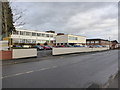
Industry on Hewell Road, Redditch
Closest is the cream frontage of Peterson Spring. This is a US-based company established in 1914 and this is the UK manufacturing plant. Not surprisingly, springs feature heavily in the company's portfolio. The brick works beyond is A Poole & Son Ltd, another spring manufacturer.
Redditch specialised in the manufacture of needles initially with hooks and springs developing later. There is still quite a lot to see around and about.
Image: © Chris Allen
Taken: 23 Dec 2014
0.23 miles