IMAGES TAKEN NEAR TO
Nutford Street, REDDITCH, B97 6DG
Introduction
This page details the photographs taken nearby to Nutford Street, B97 6DG by members of the Geograph project.
The Geograph project started in 2005 with the aim of publishing, organising and preserving representative images for every square kilometre of Great Britain, Ireland and the Isle of Man.

There are currently over 7.5m images from over14,400 individuals and you can help contribute to the project by visiting https://www.geograph.org.uk
Image Map
Images are licensed for reuse under creativecommons.org/licenses/by-sa/2.0
Notes
- Clicking on the map will re-center to the selected point.
- The higher the marker number, the further away the image location is from the centre of the postcode.
Image Listing (4 Images Found)
Images are licensed for reuse under creativecommons.org/licenses/by-sa/2.0
Image
Details
Distance
1
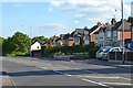
Houses on the old Birmingham Road now fronting Alvechurch Highway, Redditch
Image: © Robin Stott
Taken: 2 Jun 2013
0.21 miles
2
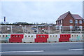
Millwood Meadows
A new greenfield Bovis housing development still under construction.
Image: © Bill Boaden
Taken: 17 Mar 2017
0.23 miles
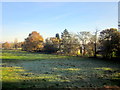
4

Mettis Aerospace, Redditch
It is impossible to do this 28 acre temple of heavy industry justice with any terrestrial photograph. Originally known as High Duty Alloys - HDA - it was built in 1937 to make pistons for Rolls Royce Merlin engines (more than 10 million made). The site is still very much in business making high-duty forgings for the aerospace industry - particularly turbine blades and undercarriage legs. The workshops contain a delightful array of brutal metal-bashing equipment, culminating in a 16,000 ton hydraulic press.
A colleague has had the pleasure of a visit here but there is strictly no photography inside.
Image: © Chris Allen
Taken: 23 Dec 2014
0.25 miles