IMAGES TAKEN NEAR TO
Cruise Hill Lane, REDDITCH, B97 5TR
Introduction
This page details the photographs taken nearby to Cruise Hill Lane, B97 5TR by members of the Geograph project.
The Geograph project started in 2005 with the aim of publishing, organising and preserving representative images for every square kilometre of Great Britain, Ireland and the Isle of Man.

There are currently over 7.5m images from over14,400 individuals and you can help contribute to the project by visiting https://www.geograph.org.uk
Image Map
Images are licensed for reuse under creativecommons.org/licenses/by-sa/2.0
Notes
- Clicking on the map will re-center to the selected point.
- The higher the marker number, the further away the image location is from the centre of the postcode.
Image Listing (8 Images Found)
Images are licensed for reuse under creativecommons.org/licenses/by-sa/2.0
Image
Details
Distance
1
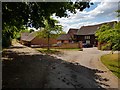
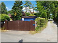
Converted barns at Crosslanes Farm, Ham Green
On the left of the barns is a bridleway whose signpost is shown in Image
Image: © Jeff Gogarty
Taken: 13 Jun 2020
0.02 miles
2
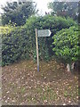
Bridleway to Cruise Hill signpost, Crosslanes
Image: © Jeff Gogarty
Taken: 13 Jun 2020
0.02 miles
3

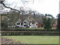
Crosslanes Farmhouse, Ham Green, Worcestershire
From Pevsner "Cross Lanes Farmhouse, 3/8 m. N of Ham Green.
A Farmhouse of c1620 consisting of two bays in the hall range and an ornately timbered two-bay cross-wing."
Image: © Jeff Gogarty
Taken: 13 Jun 2020
0.03 miles
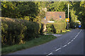
5
Footpath by the side of Holly Cottage, Ham Green
Image: © Jeff Gogarty
Taken: 13 Jun 2020
0.11 miles
6
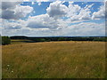
View towards the distant Malvern Hills
From Cruisehill Lane, Ham Green, Worcestershire.
Image: © Jeff Gogarty
Taken: 13 Jun 2020
0.14 miles
7
Elcocks Brook Farm
Converted farm buildings at Elcocks Brook farm
Image: © P Gaskell
Taken: Unknown
0.21 miles