IMAGES TAKEN NEAR TO
Enfield Road, REDDITCH, B97 5NH
Introduction
This page details the photographs taken nearby to Enfield Road, B97 5NH by members of the Geograph project.
The Geograph project started in 2005 with the aim of publishing, organising and preserving representative images for every square kilometre of Great Britain, Ireland and the Isle of Man.

There are currently over 7.5m images from over14,400 individuals and you can help contribute to the project by visiting https://www.geograph.org.uk
Image Map
Images are licensed for reuse under creativecommons.org/licenses/by-sa/2.0
Notes
- Clicking on the map will re-center to the selected point.
- The higher the marker number, the further away the image location is from the centre of the postcode.
Image Listing (6 Images Found)
Images are licensed for reuse under creativecommons.org/licenses/by-sa/2.0
Image
Details
Distance
1
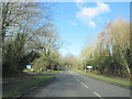
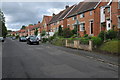
B4504 Windmill Drive Redditch Near Dunlop Road
Image: © Roy Hughes
Taken: 5 Feb 2018
0.09 miles
2
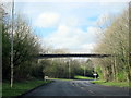
Footbridge Over Windmill Drive Hunt End Redditch
Image: © Roy Hughes
Taken: 4 Apr 2016
0.11 miles
3
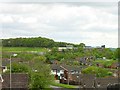
St Augustine's Catholic High School
Looking south south west from Forest View.
Image: © Penny Mayes
Taken: 5 May 2005
0.16 miles
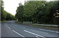
6
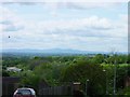
Blue Remembered Hills
Looking south west across the square from Forest View, Crabbs Cross. The distant hills are the Malverns. As so often happens in Redditch, the houses can't be seen for the trees.
Image: © Penny Mayes
Taken: 5 May 2005
0.22 miles