1
East end of public garden, former burial ground, Rectory Road, Redditch
The ground was associated with the former St Luke's Church in Evesham Road to the west
Image The land was given by Baroness Windsor. The earliest 1:2500 OS map on which it is shown as a burial ground is that of 1904. The map of 1968-73 is the first to show it as Public Garden. A number of memorials have been retained around the perimeter, together with the one in the central feature
Image
Image: © Robin Stott
Taken: 4 Sep 2013
0.03 miles
2
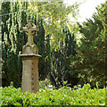
Memorial retained in former burial ground, Rectory Road, Headless Cross, Redditch
It emerges from dense shrubs, planted perhaps to deter vandalism. The inscription is difficult to decipher; it could start "In Eternal Remembrance / of / Thomas Best and Anne…" Deserves another visit.
Image: © Robin Stott
Taken: 4 Sep 2013
0.03 miles
3
Southeast corner of former burial ground, Rectory Road, Headless Cross, Redditch
A number of memorials have been retained around the perimeter of the public garden, together with the one in the central feature
Image
Image: © Robin Stott
Taken: 4 Sep 2013
0.03 miles
4
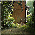
Gates for access to St Luke?s Cottages, Rectory Road, Headless Cross, Redditch
The retained memorial seen in
Image is seen here sideways on. The gates perhaps date from the creation of the public garden in the 1960s, to supplement the lych gate
Image
Image: © Robin Stott
Taken: 4 Sep 2013
0.03 miles
5
West on Rectory Road, Headless Cross, Redditch
This pleasant street once ran through to the Evesham Road from the Birchfield Road. It was severed by the A448 Bromsgrove Highway in the days of the New Town.
Image: © Robin Stott
Taken: 4 Sep 2013
0.04 miles
6
Public garden, former burial ground, Rectory Road, Headless Cross, Redditch
The ground was associated with the former St Luke's Church in Evesham Road to the west
Image The land was given by Baroness Windsor. The earliest 1:2500 OS map on which it is shown as a burial ground is that of 1904. The map of 1968-73 is the first to show it as Public Garden.
Image: © Robin Stott
Taken: 4 Sep 2013
0.05 miles
7
Lych Gate to former burial ground, Rectory Road, Headless Cross, Redditch
A little plaque on the front reads: "1861 / Lych-Gate / Built by subscription for the / burial ground donated by / Baroness Windsor". It was consecrated in the same year (this information came from 'Jack', who found it in the 1900 Kelly's Directory of Worcestershire). The plaque itself is of an engraved material with the text in a Gill Sans typeface, introduced in 1930: perhaps it is a replacement for the original. http://forebears.co.uk/england/worcestershire/headless-cross
Image: © Robin Stott
Taken: 4 Sep 2013
0.05 miles
8
Auto-parts shop, Redditch
A distinctive blue building at the junction of Rectory Road and Plymouth Close.
Image: © Jonathan Billinger
Taken: 22 Dec 2008
0.05 miles
9
Plymouth Close, Headless Cross, Redditch
Plymouth Close was originally the southern end of Plymouth Road, which first appears on the OS 1:2500 map of 1927 partly developed for houses. It was a direct route into the town centre from the Birchfield Road in Headless Cross. Plymouth Road was severed by the A448 Bromsgrove Highway through the New Town and diverted to join the Evesham Road. Plymouth Close now leads to more recent housing developments sandwiched between the Birchfield Road and the A448. A pedestrian subway connects to Plymouth Road, the rail station and the town centre.
Image: © Robin Stott
Taken: 4 Sep 2013
0.06 miles
10
Plymouth Close entry to pedestrian subway under the A448, Headless Cross, Redditch
It leads to Plymouth Road which, before it was severed by the A448 through the New Town, was a handy direct route to and from the original town centre – still possible on foot or bike, of course. Plymouth Road first appears on OS 1:2500 maps in 1927, already partly ribbon-developed with detached and semi-detached houses.
Image: © Robin Stott
Taken: 4 Sep 2013
0.07 miles


