IMAGES TAKEN NEAR TO
Mount Pleasant, REDDITCH, B97 4JJ
Introduction
This page details the photographs taken nearby to Mount Pleasant, B97 4JJ by members of the Geograph project.
The Geograph project started in 2005 with the aim of publishing, organising and preserving representative images for every square kilometre of Great Britain, Ireland and the Isle of Man.

There are currently over 7.5m images from over14,400 individuals and you can help contribute to the project by visiting https://www.geograph.org.uk
Image Map
Images are licensed for reuse under creativecommons.org/licenses/by-sa/2.0
Notes
- Clicking on the map will re-center to the selected point.
- The higher the marker number, the further away the image location is from the centre of the postcode.
Image Listing (19 Images Found)
Images are licensed for reuse under creativecommons.org/licenses/by-sa/2.0
Image
Details
Distance
1
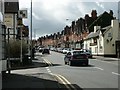
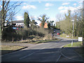
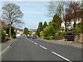
Mount Pleasant
Junction of Parsons Road with Mt Pleasant. The Woodland Cottage pub is on the western side of the road at the end of an elegant row of uniform brick-built houses.
Image: © Martin Wilson
Taken: 8 Apr 2006
0.03 miles
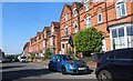
2
Mount Pleasant, Redditch
Sometimes a word is only correct in a foreign language. In this case Mount Pleasant is what is known in Yiddish as a 'mise meshinah', literally an early death, but in practice anything which ends far too soon for no good reason. It looks really useful like a proper main road but goes nowhere and to boot there is barely any room when you suddenly hit the end (which appears to have been wilfully blocked, which is why it still pretends to be a major road) to turn round. https://jel.jewish-languages.org/words/1815
Image: © David Howard
Taken: 30 May 2020
0.06 miles
3
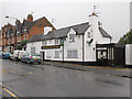
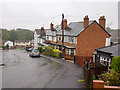
The Woodland Cottage
A public house on Mount Pleasant.
Image: © David P Howard
Taken: 6 Nov 2013
0.10 miles
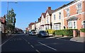
4
Laurel Close
Looking south along Laurel Close from the hilly Parsons Road.
Image: © David P Howard
Taken: 6 Nov 2013
0.12 miles
5
Corner of Pool Bank and Torrs Close, Southcrest, Redditch
The view is from the top of the drive to the extended Southcrest Manor Hotel. To the right is the steep wooded slope down from the ridge on which Headless Cross stands.
Image: © Robin Stott
Taken: 3 Apr 2013
0.14 miles
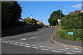
6
Parsons Road
View ENE down Parsons Road from the junction with Laurel Close.
It was a very wet November day.
Image: © David P Howard
Taken: 6 Nov 2013
0.15 miles
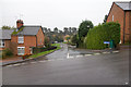
8
Salop Road at the junction of Plymouth Road
Image: © David Howard
Taken: 30 May 2020
0.18 miles
10
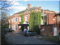
Southcrest Manor Hotel, Pool Bank, Southcrest, Redditch
The hotel looks quiet on this occasion. It appears as a hotel and venue in page after page of a Google search.
Southcrest was never a manor. It was built by Charles Terry of Herbert Terry & Sons, spring manufacturers, in 1921. Charles was a strong Methodist, a businessman and an Alderman. John Terry recalled: "I used to go [to Southcrest] and drink ginger beer. Charles would turn in his grave if he knew it was now a hotel, especially as he preached against the demon drink. The Terrys were teetotal and they insisted that other people didn't drink. You see photographs of salesmen at sales conferences – they were held at temperance hotels. All the salesmen would stand around drinking orange juice, then when the Terry family had gone home they would sneak off to the local pub."
Southcrest was acquired by the Redditch Development Corporation, who looked for someone to rent or buy it. The Sentry Insurance Company, who had a small office in Redditch, were looking for somewhere to establish their European headquarters. Negotiations had been almost finalised when an angry debate arose at a local Council meeting. Councillors objected to the fact that some trees could be felled from the Southcrest woods. Sentry Insurance took this as a loss of confidence and immediately withdrew. Consequently 400 white-collar jobs were lost.
from 'Old Redditch Voices' by Anne Bradford, Redditch: Hunt End Books, 2005, ISBN 0-9519481-4-8
Image: © Robin Stott
Taken: 3 Apr 2013
0.19 miles