IMAGES TAKEN NEAR TO
Middle Road, REDDITCH, B96 6TF
Introduction
This page details the photographs taken nearby to Middle Road, B96 6TF by members of the Geograph project.
The Geograph project started in 2005 with the aim of publishing, organising and preserving representative images for every square kilometre of Great Britain, Ireland and the Isle of Man.

There are currently over 7.5m images from over14,400 individuals and you can help contribute to the project by visiting https://www.geograph.org.uk
Image Map
Images are licensed for reuse under creativecommons.org/licenses/by-sa/2.0
Notes
- Clicking on the map will re-center to the selected point.
- The higher the marker number, the further away the image location is from the centre of the postcode.
Image Listing (3 Images Found)
Images are licensed for reuse under creativecommons.org/licenses/by-sa/2.0
Image
Details
Distance
1
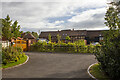
Stonehouse Farm
Converted farm buildings at Stonehouse farm
Image: © P Gaskell
Taken: Unknown
0.02 miles
2
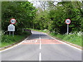
Priest Bridge
Just out of view behind the trees is the old village school which is now a private house.
Image: © Richard Dunn
Taken: 13 May 2005
0.14 miles
3
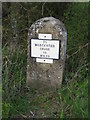
Milepost at Bradley Green
'To Worcester Cross 10 Miles'.
Image: © Philip Halling
Taken: 18 Apr 2010
0.21 miles