IMAGES TAKEN NEAR TO
Holberrow Green, REDDITCH, B96 6SB
Introduction
This page details the photographs taken nearby to B96 6SB by members of the Geograph project.
The Geograph project started in 2005 with the aim of publishing, organising and preserving representative images for every square kilometre of Great Britain, Ireland and the Isle of Man.

There are currently over 7.5m images from over14,400 individuals and you can help contribute to the project by visiting https://www.geograph.org.uk
Image Map
Images are licensed for reuse under creativecommons.org/licenses/by-sa/2.0
Notes
- Clicking on the map will re-center to the selected point.
- The higher the marker number, the further away the image location is from the centre of the postcode.
Image Listing (10 Images Found)
Images are licensed for reuse under creativecommons.org/licenses/by-sa/2.0
Image
Details
Distance
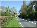
1
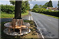
Memorial seat, Holberrow Green
A recently made memorial seat in memory of those from Holberrow Green who gave their lives in the First World War. The seat is round the trunk of an oak tree on the junction of a no through road to Morton Hall with the B4092.
Image: © Philip Halling
Taken: 18 Jun 2011
0.12 miles
2

Memorial seat, Holberrow Green
Update of https://www.geograph.org.uk/photo/2467220 from 2011.
Image: © Mike Dodman
Taken: 30 Dec 2024
0.13 miles
3
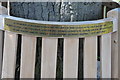
Names on a memorial seat, Holberrow Green
The names of the men of Holberrow Green who gave their lives in the First World War on a memorial seat.
Image: © Philip Halling
Taken: 18 Jun 2011
0.13 miles
4
Memorial seat, Holberrow Green
Memorial seat to the men of Holberrow Green who gave their lives in the First World War.
Image: © Philip Halling
Taken: 18 Jun 2011
0.13 miles
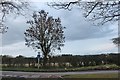
6
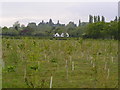
Field of newly planted trees alongside Bouts Lane.
Image: © Richard Dunn
Taken: 16 May 2005
0.18 miles
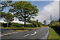
7
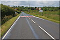
Approaching Holberrow Green
Approaching Holberrow Green on the B4092.
Image: © Philip Halling
Taken: 18 Jun 2011
0.19 miles
8

Tarbridge Farm
Update of https://www.geograph.org.uk/photo/6574062 from 2020.
Image: © Mike Dodman
Taken: 30 Dec 2024
0.24 miles
10
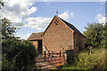
Vernacular farm buildings at Tarbridge farm
Vernacular farm buildings, brick with plain tile roofs, at Tarbridge farm
Image: © P Gaskell
Taken: Unknown
0.25 miles