IMAGES TAKEN NEAR TO
Salt Way, REDDITCH, B96 6LH
Introduction
This page details the photographs taken nearby to Salt Way, B96 6LH by members of the Geograph project.
The Geograph project started in 2005 with the aim of publishing, organising and preserving representative images for every square kilometre of Great Britain, Ireland and the Isle of Man.

There are currently over 7.5m images from over14,400 individuals and you can help contribute to the project by visiting https://www.geograph.org.uk
Image Map
Images are licensed for reuse under creativecommons.org/licenses/by-sa/2.0
Notes
- Clicking on the map will re-center to the selected point.
- The higher the marker number, the further away the image location is from the centre of the postcode.
Image Listing (10 Images Found)
Images are licensed for reuse under creativecommons.org/licenses/by-sa/2.0
Image
Details
Distance

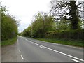
2

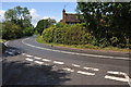
Entering New End
Heading south east on the B4090.
Image: © JThomas
Taken: 8 Apr 2017
0.10 miles
3
The B4092, Edgiock Lane
The B4092, Edgiock Lane to the south of Astwood Bank.
Image: © Philip Halling
Taken: 11 Apr 2017
0.10 miles
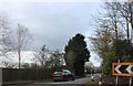
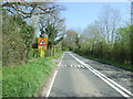
5
The B4090 near New End
sharp bend on the B4092 near New End.
Image: © Philip Halling
Taken: 18 Jun 2011
0.14 miles
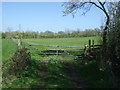
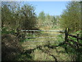
8
Footpath (beside the fence) towards the Monarch's Way
Looking north.
Image: © JThomas
Taken: 8 Apr 2017
0.19 miles